Zuma Rock as a Living Learning Landscape
ABout the Author/s


Le rocher de Zuma, monolithe de granite de 725 mètres situé le long du corridor Abuja–Zuba au Nigéria, constitue un monument national emblématique, mais demeure peu valorisé en tant que lieu d'apprentissage. Cet article propose un cadre de conception paysagère ancré dans le territoire, visant à transformer son site de 45 hectares en un « paysage vivant d'apprentissage », articulant l'éducation aux sciences de la Terre, la transmission culturelle gbagyi (gwari) et la restauration écologique. Le projet, explicitement présenté comme une recherche-conception au stade conceptuel, s’appuie sur la reconnaissance du site, une revue de la littérature et une consultation communautaire préliminaire menée dans une démarche fondée sur le consentement. Il propose cinq zones reliées entre elles : une porte d'accueil, un sentier de découverte géologique, un cercle de récits, une salle de classe en plein air et un jardin de restauration. La méthodologie met l’accent sur le principe du consentement libre, préalable et éclairé, sur la co-conception avec les aînés gbagyi et sur le partage des bénéfices, en considérant la communauté comme co-auteure. L'article formule sept principes potentiellement transférables pour transformer le patrimoine naturel passif des villes africaines en infrastructures éducatives communautaires, tout en gérant les tensions entre l'accès public, le tourisme et la protection des lieux sacrés.
Zuma Rock, the 725-metre granite monolith that guards the western approach to Nigeria's capital and appears on the 100 naira note, is among West Africa's most recognised landmarks. Yet, it remains a landscape passed by rather than learned from. This paper develops a place-based landscape design framework that reimagines the rock’s 45-hectare setting as a living learning landscape linking earth-science education, Gbagyi (Gwari) cultural transmission, and ecological restoration. The study is explicitly positioned as design research at the conceptual and schematic stage: it synthesises dated site reconnaissance, a review of place-based and critical-heritage scholarship, and preliminary, consent-based community consultation into a testable spatial proposal, not a completed build. The framework proposes five connected zones — a Gateway and Welcome Centre, a Geology Discovery Trail, a Story Circle, an Outdoor Classroom, and a Restoration Garden — each mapped to specific learners and defined curricular outcomes. Methodologically, the project foregrounds free, prior and informed consent, co-design with Gbagyi elders, and benefit-sharing, treating the community as co-author rather than subject. It is explicit about which findings are documented, which are working assumptions, and which await the next research phase. Critically, the paper situates the design within the unfinished argument between Abuja's modernist master-planning tradition and the indigenous cultural landscapes it displaced, giving sustained attention to differing community perspectives and to the real tensions among public access, tourism revenue, and the protection of sacred places. The contribution is a clear, replicable set of seven design principles — the “living learning landscape” model, each derived from a specific design decision at Zuma Rock and paired with a transferable test — for converting passive natural heritage in African cities into active, community-owned educational infrastructure, aligned with UNESCO guidance on geoheritage and cultural landscapes.
Introduction
Zuma Rock rises abruptly from the savanna near Madalla, on the boundary betweenNiger State and the Federal Capital Territory, along the busy Abuja–Zuba corridor. For the Gbagyi (also written Gwari), the people indigenous to this region, the monolith is not scenery but a presence — a dwelling for ancestral and protective spirits, a marker of belonging, and a reference point in oral tradition (Gbagyi Cultural Heritage Trust, 2020; Eze, 2020). For the modern Nigerian state, the same rock is a national emblem, printed on currency and photographed by millions of travellers each year. Between these two readings — the sacred and the scenic — lies a gap: despite its visibility, Zuma Rock is almost entirely absent from formal education and is treated as a roadside spectacle rather than a place of learning.
This paper argues that the gap is not merely a missed tourism opportunity but a pedagogical and cultural loss. Nigerian curricula in the sciences and social studies are widely criticised for their abstraction and disconnection from local environments, a disconnection felt acutely in a region where a world-class geological and cultural resource lies within sight of classrooms (Gruenewald, 2020; Eze, 2020). At the same time, the rapid, largely unplanned expansion of the Abuja–Zuba corridor is eroding the very cultural landscapes that give the rock its meaning. This study therefore asks two questions: how might intentional landscape design turn Zuma Rock into a living classroom, and how might that design also protect Gbagyi cultural meaning from the pressures of modernist, capital-city urbanisation?
The response presented here is a place-based landscape design framework — the “living learning landscape” — in which every path, gathering space and planted area serves an educational and cultural function while remaining under community stewardship. The paper outlines the project's stage of development, intended audiences and curricular applications, participatory methodology, and scholarly contribution before presenting the spatial framework and a set of transferable design principles (Gruenewald, 2020; UNESCO, 2021; Smith, 2006).
Stage of Development and Project Status
To avoid overstating its claims, this project must be read for what it is: a design-research proposal at the conceptual and schematic stages, not a completed or funded construction project. This framing matters both intellectually — it defines the kind of evidence the study can offer — and practically, as it tells partners and funders exactly where the work stands and what would be required to advance it.
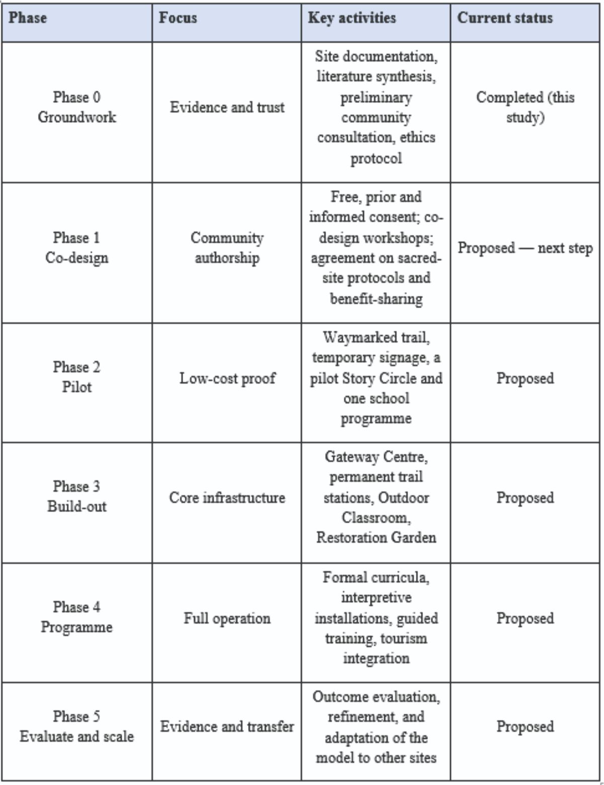
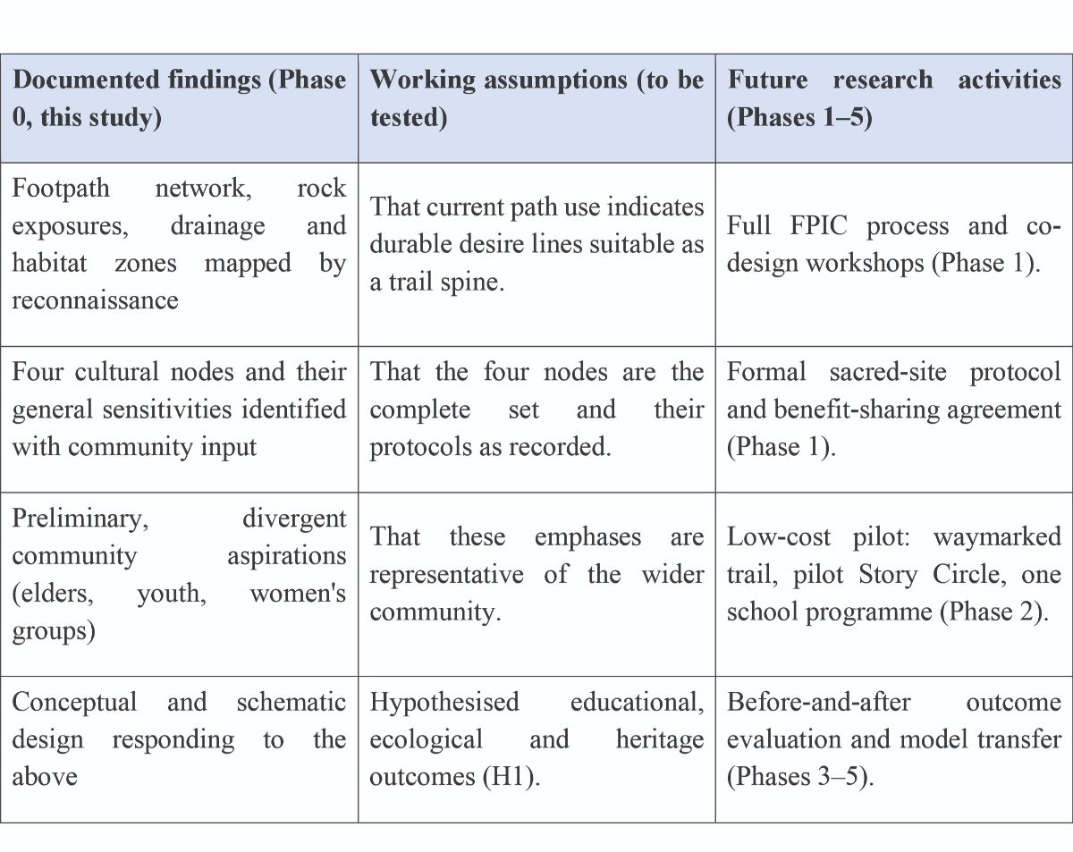
Three strands of work are complete and form the evidence base for the proposal. First, desk-based and field reconnaissance of the 45-hectare study area has documented its principal rock exposures, vegetation zones, seasonal drainage, and the footpaths and cultural nodes residents already use. Second, a review of place-based education, geoheritage, critical-heritage, and African-urbanism scholarship has established the conceptual framework. Third, preliminary, consent-based consultation with Gbagyi community members and cultural custodians has identified the meanings, sensitivities, and aspirations that any design must respect. What has not yet been done is equally important to state plainly: no detailed engineering, costing, environmental-impact assessment, or formal land-tenure agreement exists, and the educational outcomes described later are hypothesised targets to be tested, not measured results.
The framework is therefore best understood as a structured hypothesis about how design can produce learning and cultural outcomes, together with a phased pathway for testing it. Table 1 sets out that pathway and, crucially, distinguishes completed work from what remains, enabling incremental adoption and evaluation at each step (UNESCO, 2021; Yakubu, 2020).
Aim, Objectives and Research Questions
Aim. To develop a critical, replicable place-based landscape design framework that transforms the Zuma Rock setting into a living learning landscape supporting earth-science education, Gbagyi cultural transmission, ecological restoration and community stewardship, while mediating between indigenous heritage and the modernist urbanisation of the Abuja–Zuba corridor (Gruenewald, 2020; UNESCO, 2021; Watson, 2009).
Objectives
• Document the geological, ecological and cultural features of the Zuma Rock landscape that have educational and heritage value (Bello & Ibrahim, 2021; Gbagyi Cultural Heritage Trust, 2020).
• Integrate Gbagyi indigenous knowledge and place-based education theory through a co-design process that positions the community as author rather than subject (Eze, 2020; Yakubu, 2020; Smith, 2006).
• Design a multi-zone framework comprising geological trails, storytelling spaces, outdoor classrooms and restoration areas, each mapped to specific audiences and curricular outcomes (Kabisch et al., 2022; UNESCO, 2021).
• Situate the design critically within the relationship between heritage, modernist planning and contemporary African cities (Elleh, 2001; Watson, 2009; Myers, 2011).
• Distil a replicable set of design principles for converting passive natural heritage across African cities into active, community-owned educational landscapes (UNESCO, 2021; Yakubu, 2020).
Research questions
• Which geological, ecological and cultural features of Zuma Rock can be utilised for place-based environmental and cultural education?
• How can Gbagyi cultural meanings be integrated with modern landscape design without diminishing the site's sacred significance?
• How can design mediate the tension between indigenous heritage and the modernist planning ethos of the Abuja–Zuba corridor?
• What design and governance strategies secure community ownership and ensure long-term sustainability, and how transferable are they to other African sites?
Hypothesis
H1: A carefully designed, community-owned, place-based landscape centred on an iconic natural landmark such as Zuma Rock will improve environmental and cultural learning outcomes and strengthen heritage stewardship more than conventional classroom instruction.
H0: Converting a natural heritage site into a designed educational landscape will produce no significant difference in environmental learning, cultural transmission or community engagement (Gruenewald, 2020).
Conceptual Framework and Literature Review
Place-based education and outdoor learning
Place-based education grounds learning in the local environment, culture and community, using the immediate surroundings as the primary text. Gruenewald (2020) argues that grounding curricula in local landscapes increases engagement, builds ecological identity, and re-politicises education by asking who a place is for and who decides its future. Outdoor classrooms extend this by moving learning into direct contact with living systems, which is especially valuable in Nigeria, where science teaching is often delivered abstractly and at a distance from the phenomena it describes. The living learning landscape applies these ideas literally: the site itself becomes the curriculum.
Geoheritage and geological education
Geological heritage sites offer unusually direct opportunities for earth-science learning. Bello and Ibrahim (2021) note that Nigerian inselbergs, such as Zuma Rock, have exceptional educational value because processes normally described only in textbooks — exfoliation, jointing, weathering, and the granite–country-rock contact — are visible and accessible at human scale. Interpretive trails and tactile, multilingual stations can translate this into accessible learning for a wide range of ages and abilities, positioning the rock as a national reference specimen for the earth sciences rather than merely a photogenic backdrop (UNESCO, 2021).
Gbagyi (Gwari) cultural meanings and indigenous knowledge
For the Gbagyi, Zuma Rock is a living cultural landscape in the sense used by UNESCO and by critical-heritage scholars: a place where nature and human meaning are inseparable (UNESCO, 2021; Smith, 2006). Oral tradition reads the monolith as a sacred residence for protective and ancestral spirits and, in some accounts, as a guardian marking the edge of Gbagyi territory; the weathered profile, widely described as a “human face”, is understood not as coincidence but as evidence of that presence (Gbagyi Cultural Heritage Trust, 2020; Eze, 2020). Meaning here is enacted, not merely remembered: specific clearings, groves and rocks at the base host ceremonies, medicinal-plant harvesting and intergenerational instruction; Gbagyi ecological knowledge — of plant uses, seasonal cycles and stewardship obligations — is transmitted orally through these practices.
That meaning, however, is not held uniformly across the community, and the design cannot treat “the Gbagyi view” as singular. The preliminary consultation revealed recognisably different emphases. Custodial lineages and senior elders emphasised the shrine grove’s inviolability and the conditions under which sacred knowledge may be spoken, recorded or shown to outsiders. Youth and some working-age men emphasised employment, skills and the income a well-run visitor landscape could bring, and were markedly more open to tourism. Women's groups, who hold much of the medicinal-plant and seasonal-harvest knowledge, were concerned above all with continued physical access to gathering areas and with being credited and remunerated if that knowledge is interpreted for visitors. These are not merely demographic nuances; they are competing, legitimate claims on the same ground, and a design that satisfies one constituency can disadvantage another. The framework therefore does not resolve these differences in advance but builds a governance structure (Section 5.3) capable of holding them.
This has a direct design consequence. If cultural knowledge lives in practice and place, education about it cannot be reduced to signage or display without loss; it must keep the practices and their custodians active on site. Yakubu (2020) warns that design in African heritage landscapes too easily slides into extraction — harvesting stories and motifs for a visitor product while displacing the community that gives them meaning. The framework therefore treats Gbagyi custodians as authors and the sacred nodes as protected, community-controlled spaces rather than exhibits, following the logic of the “authorised heritage discourse” critique that heritage value is negotiated, not simply defined by experts (Smith, 2006).
The access–tourism–sacredness tension
The single hardest problem the design must address is the three-way tension among public access, tourism revenue, and the protection of sacred places — a tension the literature largely treats abstractly, yet is concrete here. Public access is the project's pedagogical reason for being: a learning landscape that the public cannot enter teaches no one. Tourism is the most plausible revenue source that could make the landscape self-sustaining and provide the local employment the youth consultation prioritised. Yet both press directly against the custodians' requirement that certain nodes — above all the shrine grove — remain restricted, unphotographed, and governed by ceremonial rather than visitor calendars. Commodification is a real risk: the “human face” and the shrine are exactly the images a tourism product would be tempted to foreground, which is the extraction Yakubu (2020) describes.
The framework's response is not to pretend the tension away but to manage it spatially and procedurally: a zoned gradient from fully public (trail, garden, classroom) through semi-public (Story Circle, used on the community's terms) to restricted (sacred nodes, with access and interpretation controlled by custodians under FPIC); a revenue model in which tourism funds access rather than dictating it; and a veto, held by custodians, over what may be interpreted or shown at all (Smith, 2006; Yakubu, 2020). This makes the sacred the organising constraint on access and tourism, rather than a feature to be marketed.
Heritage, modernist planning and contemporary African cities
Zuma Rock cannot be read apart from Abuja. The Federal Capital was conceived in the 1970s as a deliberately modernist, master-planned city — a rational, ethnically neutral “national” capital laid out on a monumental grid, and one of the twentieth century's most ambitious urban-design projects (Elleh, 2001; Vale, 2008). Like other planned capitals, its logic was top-down and universalising, treating the pre-existing indigenous landscape as a blank site to be organised rather than a set of living places to be engaged (Vale, 2008; Myers, 2011). The Gbagyi, the region's original inhabitants, were substantially displaced by the capital's creation, and the Abuja–Zuba corridor now urbanises rapidly along the same modernist grain.
Critical scholarship on African urbanism argues that planning models imported from the global North frequently misread African realities and marginalise the informal, the customary and the sacred (Watson, 2009; Myers, 2011). Zuma Rock sits precisely on this fault line: a Gbagyi sacred landscape nationalised as a modernist icon on the currency. At the same time, its cultural custodians are pushed to the margins of the growing city. In this light, the framework proposed here is a critical intervention that uses landscape design to hold heritage and modernity in productive tension, rather than freezing the rock as a scenic monument or surrendering its setting to corridor sprawl. The built implications of that stance are developed in Section 7.4; they are not restated here.
Nature-based solutions and landscape restoration
Landscape design can serve ecological and educational purposes simultaneously. Kabisch et al. (2022) show that nature-based solutions — native planting, rainwater harvesting and green corridors — support biodiversity and climate adaptation, while Obiefuna (2021) highlights the pressing need to address soil degradation and biodiversity loss in the northern savanna. The proposed Restoration Garden operationalises these findings as a living laboratory and seed bank (Federal Ministry of Environment, 2023).
Gap in the literature and scholarly contribution
Place-based education, geoheritage, indigenous knowledge studies and critical African urbanism are each well developed. However, they are rarely brought together at a single site, and even less often operationalised as a buildable, community-owned design. This study contributes in three ways. First, it integrates these literatures into a single spatial framework at a nationally iconic site, showing how abstract debates about heritage and modernity can be resolved through concrete design decisions. Second, it advances a critical, community-authored model of place-based landscape design that explicitly guards against the extraction Yakubu (2020) warns of. Third, it distils the result into a transferable set of design principles — the living learning landscape model — offered as replicable infrastructure for other African cities confronting the same tension between planned modernity and indigenous heritage (Smith, 2006; Watson, 2009; UNESCO, 2021).
Methodology and Community Engagement
The study uses a mixed-methods, design-research approach in which analysis and design proceed together: evidence about the site and community shapes the design, and the design in turn raises questions that send the inquiry back to the site and community. This section sets out not only the methods but also when and how the fieldwork and consultation were carried out, who took part, and how each finding informed a specific design decision — and it separates what is documented from what remains a working assumption or a future activity.
Timing and conduct of the fieldwork and preliminary consultation
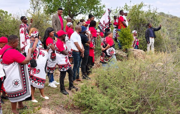
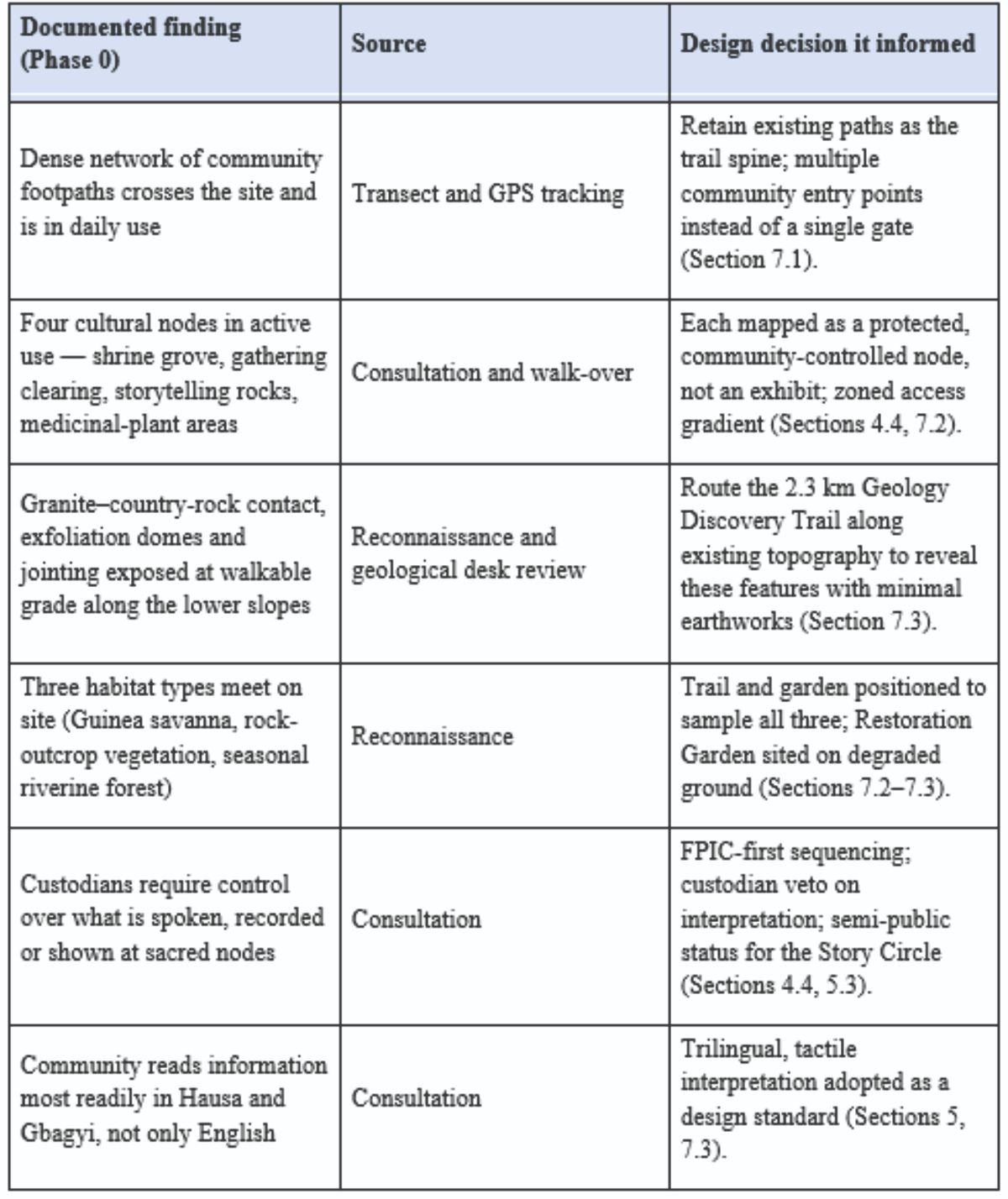
The groundwork (Phase 0) was carried out in April and May 2026 across two linked tracks. The site reconnaissance comprised four day visits to the 45-hectare study area, combining a walking transect of the existing footpath network, handheld GPS tracking of paths and nodes, photographic documentation of rock exposures and drainage lines, and desk-based analysis of satellite imagery and available geological mapping. The team compiled observations into the biophysical and cultural inventory summarised in Section 7.2. The reconnaissance was exploratory and non-intrusive: no excavation, no instrumented survey, and no entry to restricted areas without a custodian present.
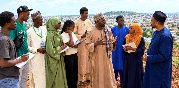
The preliminary consultation was conducted in parallel, led by the author with a Gbagyi-speaking facilitator, and comprised 5 semi-structured conversations and 2 small group discussions with a purposive sample of Gbagyi participants identified through community referral: senior elders and custodial-lineage representatives, members of a women's medicinal-plant group, and younger community members. Participation was voluntary and consent-based; participants were told the work was a design study, not a committed build, and were free to decline any question or to request that specific information not be recorded. Conversations were documented in field notes (audio recording only where explicitly permitted) and analysed through thematic coding to identify site meanings, sensitivities, and aspirations. This consultation is explicitly preliminary and indicative; it is not, and is not presented as, a full free, prior and informed consent (FPIC) process — that is the first proposed next step (Phase 1).
From findings to design decisions
The value of the groundwork is that specific, documented findings produced specific design moves rather than generic good intentions. Table 2 makes this traceable.
What is documented, what is assumed, and what comes next
To keep the evidence base transparent, Table 3 separates the three categories that are often blurred in heritage proposals.
The four methodological components
Site assessment and mapping. A biophysical and cultural inventory of the 45-hectare zone based on field surveys, GPS/GIS and geological documentation, covering rock exposures, vegetation, drainage, and the footpaths and cultural nodes already used by Gbagyi residents (Bello & Ibrahim, 2021; Gbagyi Cultural Heritage Trust, 2020).
Indigenous knowledge integration. Consent-based, semi-structured interviews and participatory workshops with Gbagyi elders, custodians and community leaders to record place names, narratives, medicinal plant knowledge and sacred-site protocols, with data analysed through thematic coding (Eze, 2020; Yakubu, 2020).
Design development. Application of landscape design principles and place-based education theory to develop the five zones, with interpretive content proposed in trilingual English, Hausa and Gbagyi (Kabisch et al., 2022; Gruenewald, 2020).
Evaluation design. A framework of indicators — educational, ecological and heritage — with before-and-after assessment and community feedback, specified in Section 9, so that the pilot phase can generate the evidence the proposal currently lacks (Obiefuna, 2021; UNESCO, 2021).
Ethics of engagement: consent, co-design and benefit-sharing
Because the site is sacred and the community has been historically marginalised, the methodology treats community engagement as an ethical architecture, not a consultation formality. Three commitments govern it. First, free, prior and informed consent (FPIC): the community is engaged before design decisions are finalised, with the explicit right to withhold consent for any element, particularly at sacred nodes, and to set conditions on what may be documented, photographed or interpreted (Yakubu, 2020; Smith, 2006). Second, co-design and co-authorship: Gbagyi custodians participate as designers of the cultural components, holding decision rights over how their knowledge is represented, so that the landscape expresses the community's account of itself rather than an outsider's. Third, benefit-sharing and ownership: residents are positioned as guides, gardeners, craftspeople, storytellers and managers, and a shared-governance structure — a management committee with a community majority — is proposed so that both revenue and control remain substantially local. These commitments directly address the extraction risk identified in the literature and are the mechanism by which the project claims to protect, rather than commodify, Gbagyi meaning (Yakubu, 2020; Eze, 2020).
Two caveats keep the account honest. The consultation completed so far is preliminary and indicative, not a full FPIC process; the latter is proposed as the first step (Phase 1) precisely because it must precede binding design. And the “community” is not monolithic — as Section 4.3 sets out, elders, youth, women's groups and custodial lineages hold different views — so the governance design deliberately provides for plural voices and a custodian veto rather than a single spokesperson.
Intended Audience and Educational Application
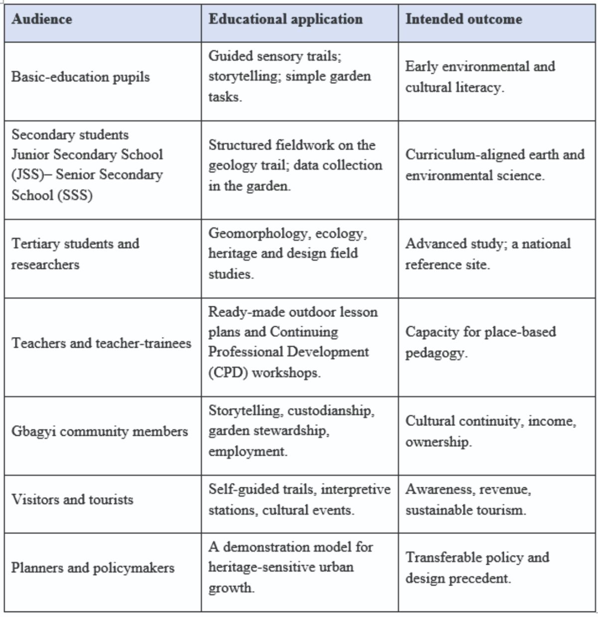
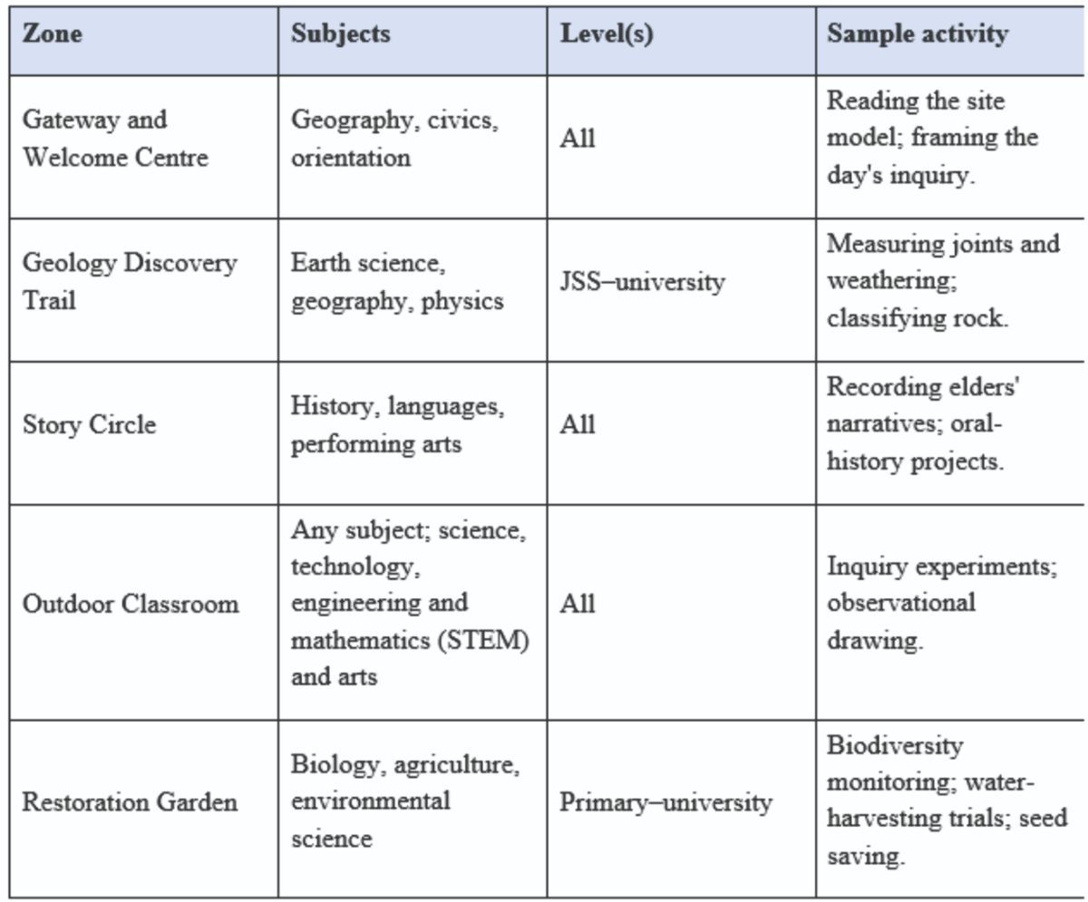
A recurring weakness in heritage-site proposals is vagueness about who will learn what. This framework specifies its audiences and the concrete educational uses each will make of the landscape. Table 4 sets out the primary audiences and their applications; Table 5 maps the five zones to curricular subjects, levels and sample activities, showing that the landscape is usable from basic education through to university and community learning.
Design Framework and Discussion
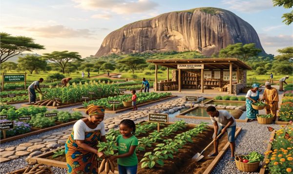
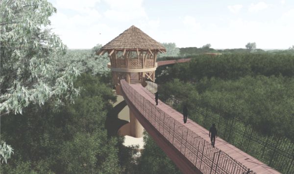
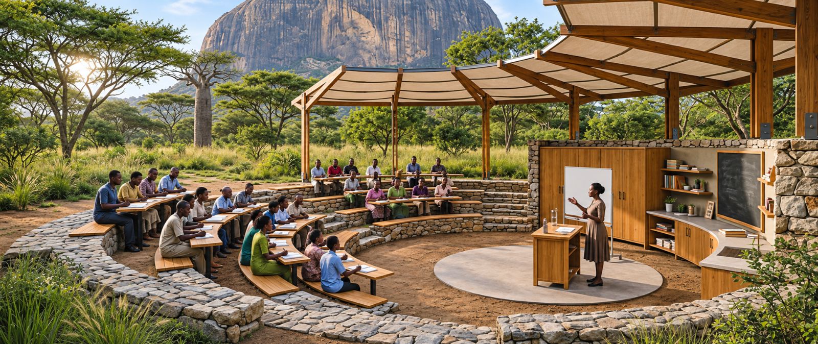
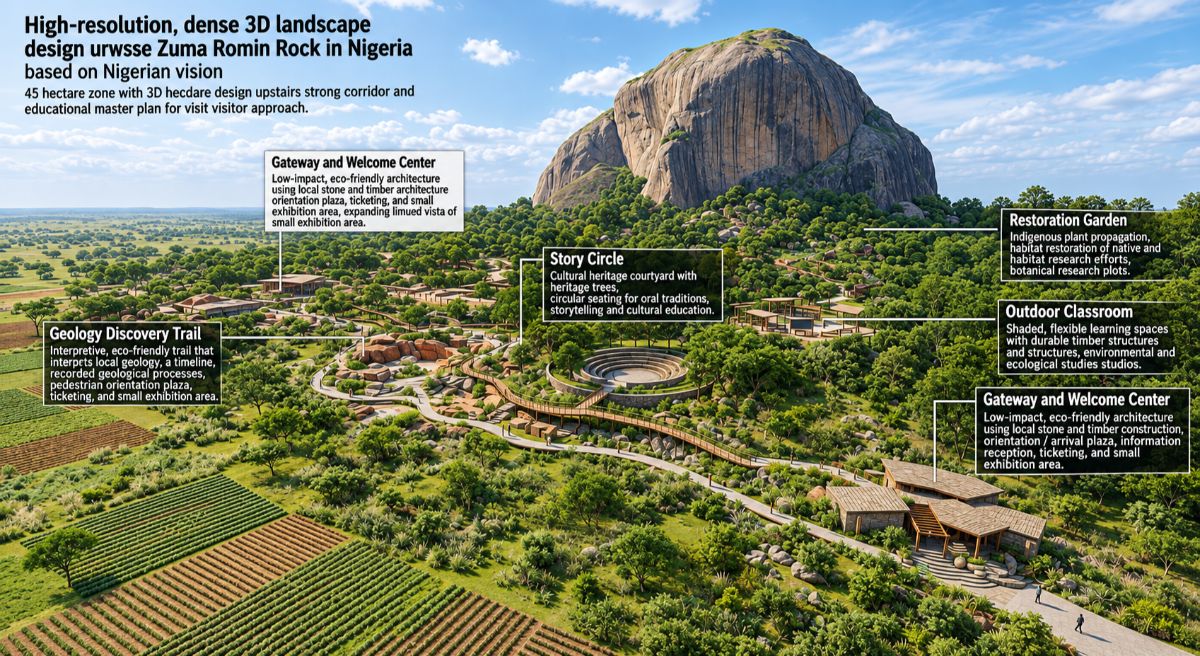
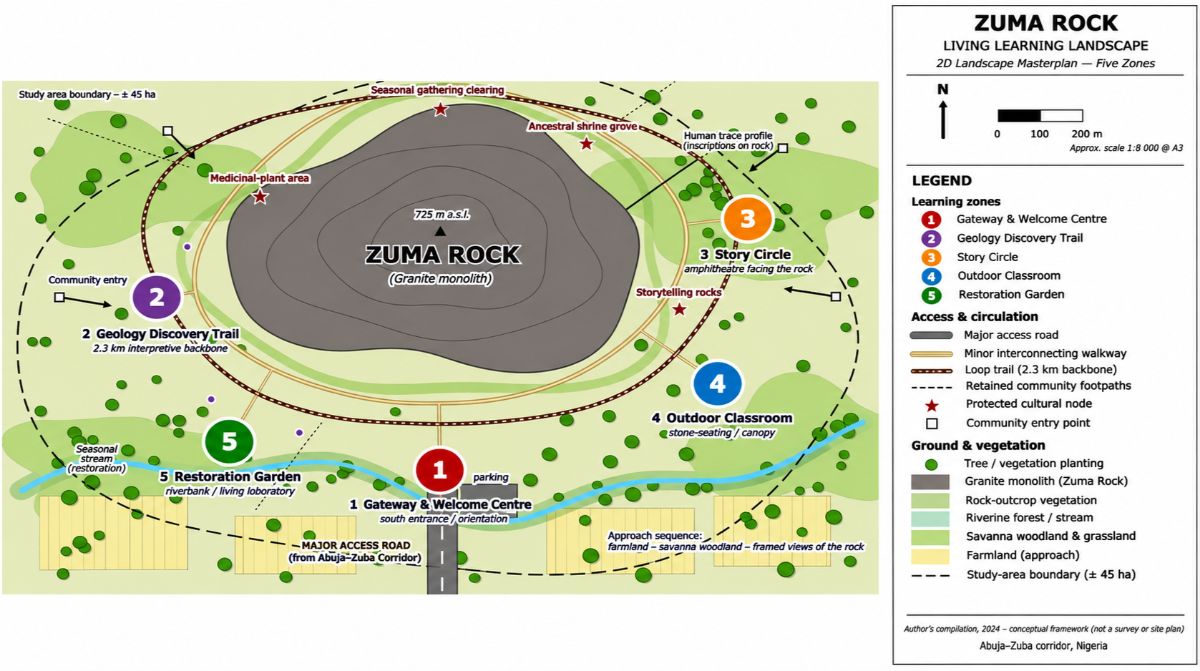
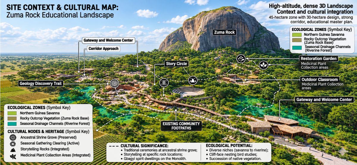
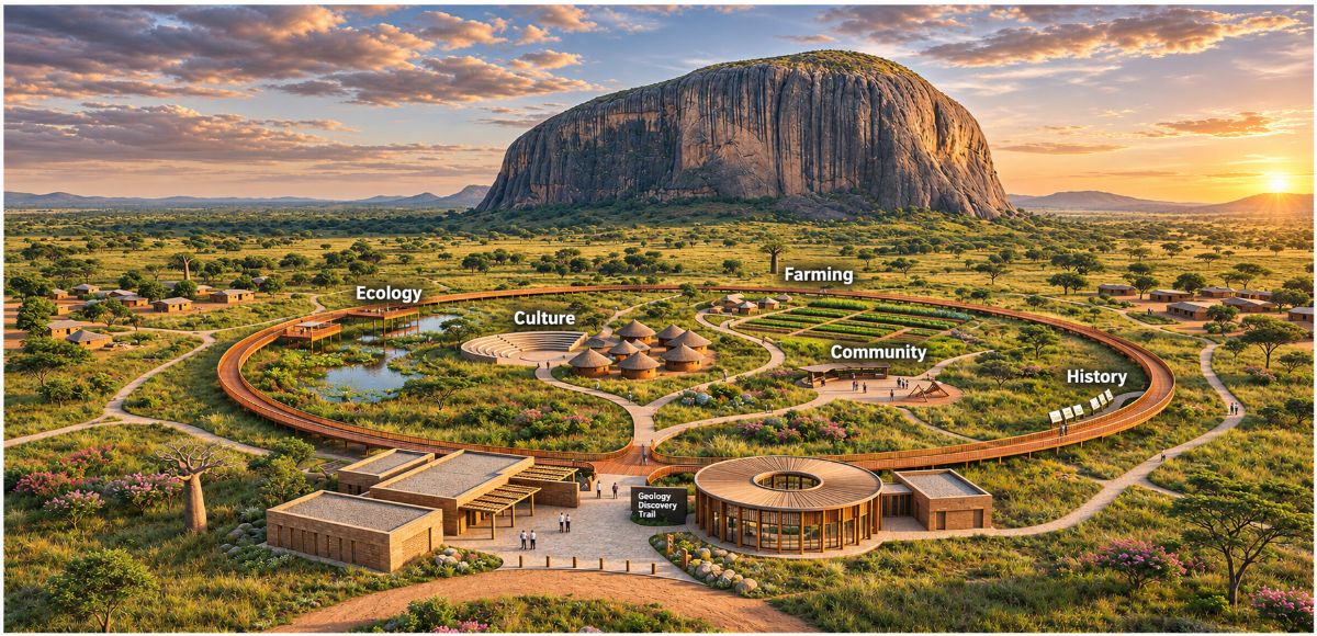
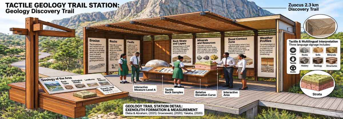
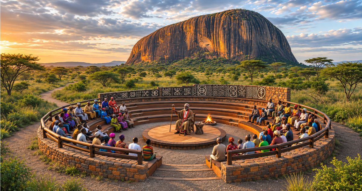
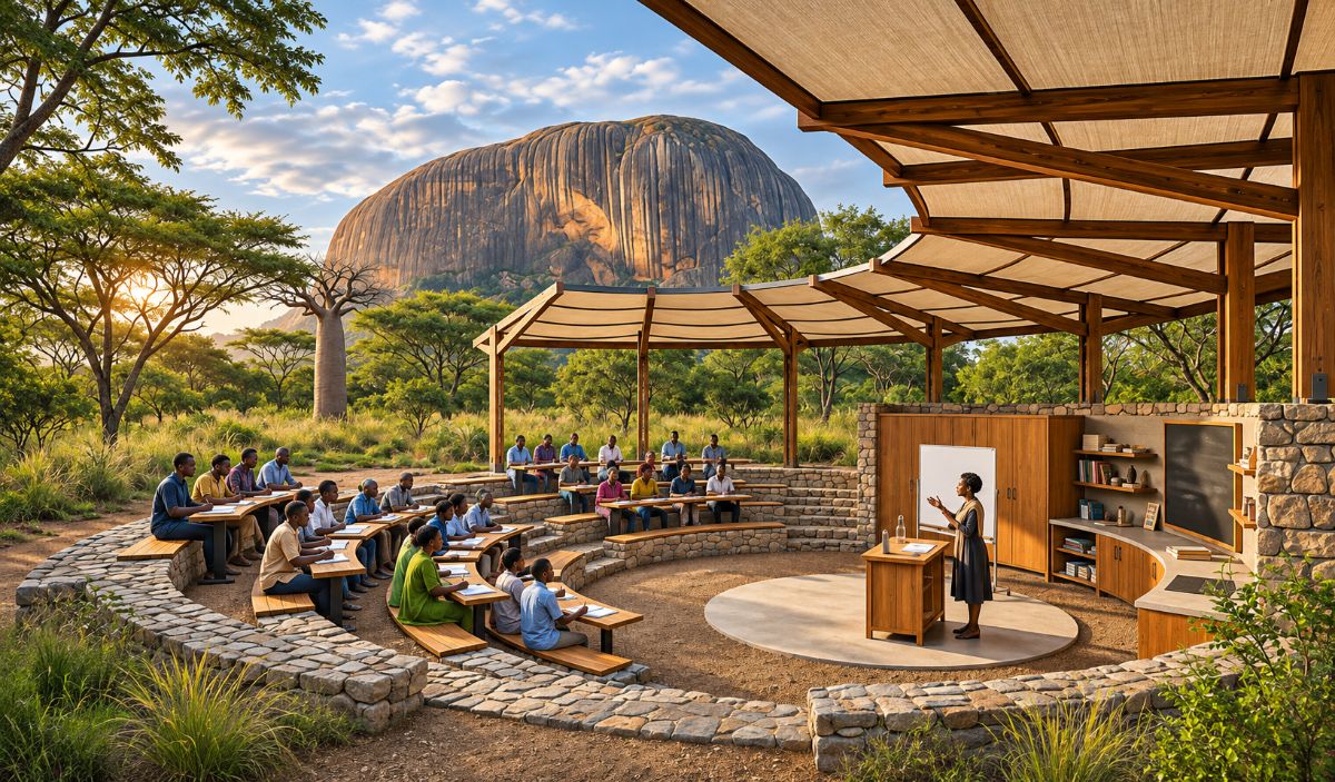
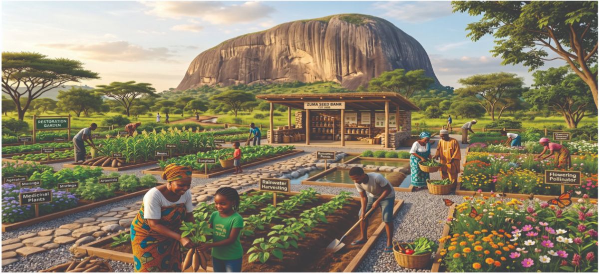
A note on the figures. To keep the visual argument honest, each figure is labelled by type. Conceptual visualisations (Figures 1, 4–8) are design impressions of proposed, not-yet-built elements. Survey-based diagrams (Figures 2 and 3) record existing site conditions — paths, habitats and cultural nodes documented during the Phase 0 reconnaissance — and include a legend and enlarged labelling for legibility. Readers should not mistake the rendered impressions for existing on-the-ground conditions.
Vision and spatial strategy
The framework covers a 45-hectare zone around the base of the monolith, selected to encompass a range of habitats, rock exposures and culturally significant places. The approach sequence is deliberately choreographed: planting transitions from cultivated farmland to native savanna woodland, framing the rock in a series of composed views that make arrival feel like a threshold from the everyday to the extraordinary. A single loop trail links five distinct zones while keeping the monolith as the constant organising presence (Figure 1). Multiple entry points from surrounding communities keep the landscape woven into local life rather than fenced off as an isolated attraction — a design decision that directly resists the enclave logic of modernist planning (Elleh, 2001; Watson, 2009).
Reading the site: ecology and culture together
The site lies where several habitats meet — northern Guinea savanna, rocky-outcrop vegetation on the monolith itself, and riverine forest along seasonal channels (Figures 2 and 3) — supporting biology teaching from plant succession on bare granite to birds nesting in the cliff faces. Existing community footpaths are retained rather than overwritten, respecting established movement. Four primary cultural nodes were identified with community input — the ancestral shrine grove, the seasonal gathering clearing, the storytelling rocks, and the medicinal-plant areas — and each is preserved as a protected, community-controlled space, integrated into the educational route without being turned into an exhibit (Eze, 2020; Gbagyi Cultural Heritage Trust, 2020; Smith, 2006).
The five zones
Gateway and Welcome Centre. At the southern entrance, this zone offers orientation, exhibition space and basic facilities, and frames the day's inquiry (Figure 4). From here, visitors can choose the full geological circuit or shorter themed walks focused on ecology, culture or farming.
Geology Discovery Trail. The 2.3 km interpretive backbone follows the existing topography to minimise earthworks while revealing the granite–country-rock contact, exfoliation domes and xenolith inclusions. Hands-on, tactile stations — designed for accessibility, including for those with visual impairment — provide trilingual interpretation in English, Hausa and Gbagyi, enabling community members to read the science in their own language, and the rock becomes a national reference specimen (Figure 5) (Bello & Ibrahim, 2021).
Story Circle. A tiered, circular amphitheatre for up to 120 people, built from local stone and timber in an indigenous African architectural idiom and oriented towards the rock's distinctive profile. It is the physical heart of cultural transmission — a space where elders' narratives are performed and recorded, linking storytelling directly to the living landscape rather than confining it to a display case (Figure 6).
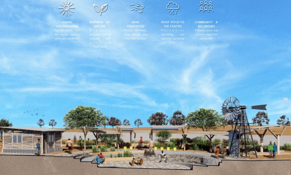
Outdoor Classroom. A flexible teaching space for up to 40 students, arranged in a semicircle of natural-stone seating facing a demonstration area, with a retractable shade canopy, work surfaces and storage. Careful acoustic design ensures teachers are heard without amplification; the space suits cooler early-morning and late-afternoon sessions (Figure 7).
Restoration Garden. A living laboratory of native medicinal plants, traditional food crops, pollinator habitat and rainwater-harvesting plots, doubling as a seed bank for locally adapted varieties. Community members maintain and harvest it, with elders sharing traditional knowledge and young people contributing to scientific monitoring — an explicit device for intergenerational exchange (Figure 8) (Kabisch et al., 2022; Obiefuna, 2021).
Holding heritage and modernity in tension
Taken together, the zones realise the paper's central critical argument in built form. The permeable, community-anchored layout refuses the fenced-enclave model; the protection of sacred nodes rejects reducing culture to spectacle; and the trilingual, tactile interpretation rejects the assumption that scientific authority must be conveyed in a colonial language. The landscape thus becomes a mediating device between the modernist, nationalised reading of Zuma Rock and its indigenous Gbagyi meaning — a concrete demonstration of how a contemporary African city might grow while keeping faith with the cultural landscape beneath it (Watson, 2009; Myers, 2011; Smith, 2006).
Toward a Replicable Framework
The value of a single site multiplies if its logic can travel. The seven principles below were not imported as a checklist; each was abstracted from a specific design decision at Zuma Rock and paired with a test by which another project can check whether it has met the principle and, where possible, measure the result. Table 6 therefore reads in three columns: the principle, the Zuma Rock decision it was derived from, and the transferable test for assessing it elsewhere. Reading the middle column alongside the Methodology and Community Egagement and Design Framework and Discussion sections, shows that the model is grounded in this case rather than asserted in the abstract.
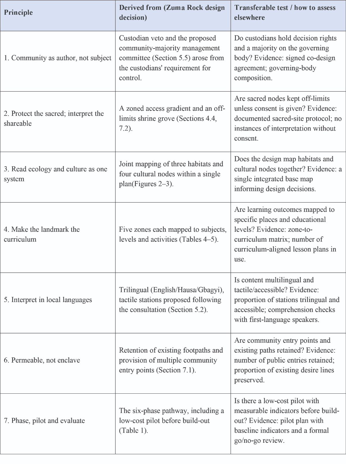
The model is offered as ahypothesis to be tested and adapted, not a template to be copied uncritically;principle 7 builds that utility into the method itself.
The model is offered as a hypothesis to be tested and adapted, not a template to be copied uncritically; principle 7 builds that utility into the method itself.
Evaluation Framework and Monitoring
Evaluation spans three linked domains — educational, environmental and heritage — and, to address the criticism that such outcomes are often left vague, Table 7 states for each a specific indicator, the instrument used to collect it, and an illustrative baseline/target to be confirmed with the community in the pilot (Phase 2). The targets are deliberately modest and explicitly provisional; their purpose is to make success checkable, not to assert results the study has not yet produced.
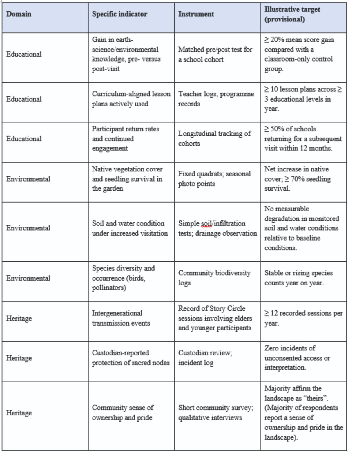
The three domains reinforce one another: learning that connects students to heritage and the environment creates advocates for preservation; restoration that involves the community strengthens tradition; and heritage programming with ecological content builds stewardship. We collect both quantitative indicators and qualitative narratives, as testing alone cannot capture the value of place-based learning. Monitoring is nested—daily logs, seasonal reviews, annual evaluations, and a five-year review—with built-in community feedback so residents can raise concerns and hold managers to account (Obiefuna, 2021; UNESCO, 2021).
Conclusion and Recommendations
This paper sets out a critical, community-authored framework for transforming Zuma Rock from a landscape passed by into one learned from. Presented honestly as a design-research proposal at the conceptual stage, it specifies its evidence base and how that evidence informed the design; its intended audiences and curricular applications; an ethical methodology built on consent and benefit-sharing; and a distinct scholarly contribution: the integration of place-based education, geoheritage, Gbagyi cultural meaning and critical African urbanism into a single, buildable, replicable design, expressed as seven derived and testable principles.
Its broader claim is that iconic natural heritage can mediate the strained relationship between indigenous cultural landscapes and the modernist, planned growth of contemporary African cities — holding heritage and modernity in productive tension rather than freezing the rock as a monument or ceding its setting to sprawl. The recommended next step is unambiguous: a full free, prior and informed consent and co-design process with the Gbagyi community (Phase 1), followed by a low-cost, well-evaluated pilot (Phase 2), so that the hypotheses advanced here can be tested using the community-based evidence they require. The framework's success will ultimately be measured not by visitor numbers but by whether Gbagyi custodians recognise the landscape as their own and whether future generations read the rock as both a place of learning and a living inheritance.
References
Bello, A.K. and Ibrahim, M.S. (2021) ‘Geological heritage of Nigerian inselbergs: Conservation and educational potential’, Nigerian Journal of Earth Sciences, 27(1), pp. 45–62.
Elleh, N. (2001) Abuja: The single most ambitious urban design project of the 20th century. Weimar: VDG.
Eze, C.U. (2020) ‘Indigenous knowledge systems and environmental management in central Nigeria’, African Studies Review, 63(4), pp. 89–107. https://doi.org/10.1017/asr.2020.45.
Federal Ministry of Environment (2023) National biodiversity strategy and action plan 2023–2027. Abuja: Federal Ministry of Environment.
Gbagyi Cultural Heritage Trust (2020) Sacred landscapes and community stewardship: Zuma Rock cultural assessment report. Abuja: GCHT Publications.
Gruenewald, D.A. (2020) ‘Place-based education: Grounding culturally responsive teaching in local communities’, in Merriam, S.B. and Bierema, L.L. (eds.) Adult learning: Linking theory and practice. San Francisco: Jossey-Bass, pp. 137–153.
Kabisch, N., Frantzeskaki, N., Pauleit, S., Naumann, S., Davis, M., Artmann, M. et al. (2022) ‘Nature-based solutions to climate change mitigation and adaptation in urban areas: Perspectives on indicators, knowledge gaps, barriers, and opportunities for action’, Ecology and Society, 27(2), article 22. https://doi.org/10.5751/ES-13132-270222.
Myers, G. (2011) African cities: Alternative visions of urban theory and practice. London: Zed Books.
Obiefuna, G.N. (2021) ‘Climate adaptation strategies for savanna ecosystems in northern Nigeria’, Journal of Environmental Management, 289, article 112456. https://doi.org/10.1016/j.jenvman.2021.112456.
Smith, L. (2006) Uses of heritage. London: Routledge.
UNESCO (2021) World heritage and sustainable development: Cultural landscapes for education and resilience. Paris: UNESCO Publishing.
Vale, L.J. (2008) Architecture, power, and national identity. 2nd edn. London: Routledge.
Watson, V. (2009) ‘Seeing from the South: Refocusing urban planning on the globe's central urban issues’, Urban Studies, 46(11), pp. 2259–2275. https://doi.org/10.1177/0042098009342598.
Yakubu, H. (2020) ‘Participatory design in African heritage landscapes’, Journal of Landscape Architecture, 15(1), pp. 34–49. https://doi.org/10.1080/18626033.2020.1727271.