Design Lessons from Igbo Courtyards, Water Storage and Village Commons: Landscape as Teacher
ABout the Author/s


Cet article examine l’apport de descriptions publiées de trois pratiques spatiales igbo à la conception paysagère contemporaine: l’organisation des cours à Akegbe Ugwu, la collecte et le stockage de l’eau à Orba, et les espaces communs et les chemins de Mgbom, à Afikpo. Une lecture interprétative distingue les descriptions des sources, les explications de leurs auteurs, l’analyse proposée et les applications envisagées. À Akegbe Ugwu, les arbres associés aux sanctuaires et les descriptions générales des plantations relient l’ombre aux activités domestiques, aux significations culturelles et à l’entretien. Orba associe le stockage domestique et collectif, l’approvisionnement saisonnier, le remplacement des récipients, les contributions et la répartition. Mgbom combine des fonctions de rassemblement à l’échelle du quartier et du village, tandis que les chemins relient les espaces communs, l’habitat et les terres productives. Trois propositions en découlent: coordonner plantations, ombre, activités, significations culturelles et entretien; prévoir le nettoyage et le remplacement dans le stockage domestique, ainsi que les responsabilités convenues dans le stockage collectif; et accueillir des usages collectifs élargis en reconnaissant les droits et revendications locaux existants. Landscape-as-Teacher désigne cette traduction en propositions situées, dont l’application exige une évaluation environnementale et sociale avec les usagers actuels.
This paper examines what published accounts of three Igbo spatial practices offer to contemporary landscape design: courtyard organisation at Akegbe Ugwu, water collection and storage in Orba, and shared spaces and routes in Mgbom, Afikpo. An interpretive reading distinguishes source descriptions, authors’ explanations, the present analysis, and proposed applications. At Akegbe Ugwu, compound-specific shrine trees and broader descriptions of courtyard planting link shade with domestic activities, cultural meaning, and care. Orba links household and communal storage with seasonal supply, individual replacement, contributions and allocation. Mgbom combines ward- and village-wide gathering roles, while compound routes connect communal space with surrounding productive land. The comparison yields three propositions: coordinate planting with shade, activities, cultural meaning and upkeep; provide for cleaning and replacement in household storage and for agreed responsibilities in shared storage; and accommodate wider collective use while recognising established local claims. Landscape-as-Teacher names this translation of documented arrangements into situated design propositions. Applying it requires assessing environmental performance alongside present users’ needs, meanings, access, and responsibilities.
Introduction
Courtyards, water-storage spaces and village commons connect buildings to vegetation, seasonal resources and collective life. Nsude (1987) documents courtyard organisation and vegetation at Akegbe Ugwu, as well as shared spaces and routes in Mgbom, Afikpo. Uzuegbu (2020) describes household and communal water storage in Orba. Reading these accounts together provides material for examining landscape design at household and settlement scales.
This inquiry belongs within established scholarship linking environmental processes, cultural practices and spatial form. Nassauer (1995) explains how cultural conventions shape landscapes and, in turn, how landscapes influence perception and behaviour. Spirn’s (2019) account of landscape literacy demonstrates how reading environmental and social histories together can inform proposals for change. These perspectives support examining physical arrangements alongside the practices through which people use and sustain them.
The paper asks: What can published accounts of three Igbo spatial practices teach contemporary landscape design about shade and outdoor use, seasonal water storage, and shared spaces and routes? Its contribution is a comparative interpretation of specific cases, making explicit the source material, reasoning and limitations behind each design proposition.
The cases differ in regional setting, scale and documentation. Akegbe Ugwu provides a compound plan and description; Orba supplies an account of household and communal storage; Mgbom offers a historical settlement map and an explanation of its commons. The analysis compares them by the design concerns each illuminates, while retaining these differences.
Landscape-as-Teacher names the process of deriving situated lessons from documented arrangements of vegetation, water, terrain and everyday life. The analysis distinguishes between source descriptions, authors’ explanations, current interpretations, and proposed applications. It asks how these arrangements can inform contemporary decisions about environmental provision, spatial use and responsibility for care.
Sources and analytical approach
This paper analyses published descriptions and drawings of three Igbo spatial practices. The cases were selected for their identifiable settings and complementary scales: household outdoor space at Akegbe Ugwu near Enugu, household and communal water storage in Orba, and shared spaces and routes in Mgbom, Afikpo. Together, they examine how habitation connects with vegetation, water, and the surrounding land while preserving regional differences in settings and social organisation.
The evidence is uneven and overlapping. Nsude (1987) provides the principal account of Akegbe Ugwu and reproduces the Mgbom map, crediting Ottenberg (1971). The latter is consulted here through Nsude. These two cases derive from a single publication, not from independent corroboration. Oluwarotimi (2026) offers a later climatic and spatial interpretation, including a modified Akegbe Ugwu plan. Uzuegbu (2020) provides a shorter account of Orba’s water practices within an archaeological study. Its detail supports analysis of storage arrangements and responsibilities but offers less spatial documentation than the other cases.
The reading distinguishes what each source records, how its author explains those observations, the present paper’s interpretation, and the design propositions that follow. Published accounts constitute evidence whose scope depends on their methods, specificity, and provenance. Adaptations of the same earlier material are not counted as independent confirmation. Three sets of questions guide the analysis.
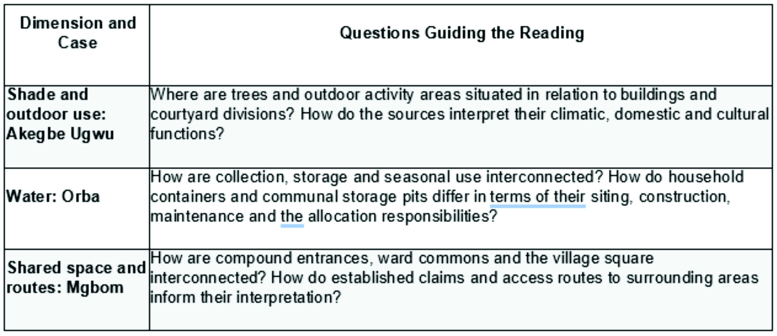
Each case examines reported functions, documented changes, gaps, and implications for contemporary design. The environmental evidence varies: climatic context and planting descriptions at Akegbe Ugwu, seasonal water collection and storage in Orba, and mapped terrain and land connections in Mgbom. These differences define the scope of comparison.
The paper presents no new fieldwork or performance measurements. Spatial and descriptive evidence supports interpretations of arrangement and use; claims about climatic effectiveness, water safety or current conditions require further evidence. The paper assesses the resulting design propositions against the available material and identifies requirements for contemporary application.
Akegbe Ugwu: Shade, courtyards and household activities
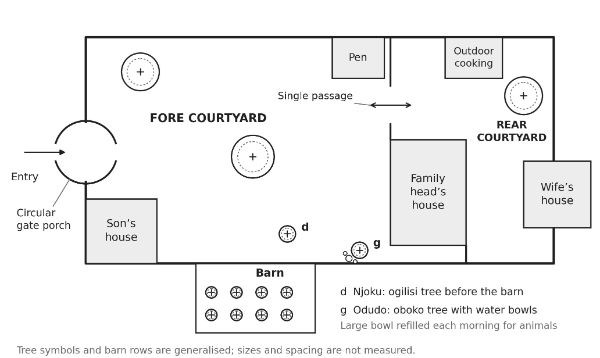
Nsude (1987, pp. 247–248, 257) records Mazi Aro Ukwu’s compound at Akegbe Ugwu, near Enugu, as a walled, single-family compound in the Igbo heartland, covering 372 m² and accommodating five people. His plan and section document the compound’s courtyard divisions, household buildings, trees and shrines.
Nsude (1987, pp. 257, 259) describes entry through a circular gate porch, ofu obodo, with the first son’s house just inside to the right. The family head’s house stood 18.5 m from the gate, facing it. Two adjoining walls divided the courtyard into fore and rear parts, linked by a single passage. The wife’s house and outdoor cooking area occupied the rear. An 84 m² barn, which Nsude interpreted as indicating the owner’s farming success, formed part of the perimeter enclosure.

Nsude (1987, p. 248, illustration 62) depicts trees within the courtyard and canopies rising above the enclosure in his plan and section. Nsude (1987, p. 281) identifies two shrine-associated trees: an ogilisi in front of the barn, symbolising njoku, associated with yam growth, and the odudo bowls, which stood beneath an oboko. The large bowl was filled each morning for domestic animals, particularly when they were confined during the growing season. Nsude (1987, p. 295), in his broader description of barns, explains that rows of living trees support poles for stacking yams. These accounts link planting with ritual observance, production and animal care, although they do not identify every courtyard tree or quantify seasonal shade.
Nsude (1987, pp. 278–279) describes courtyards as outdoor living spaces for work, meetings, play, cooking, eating and rest. Their fore/rear division separates visitor access from private domestic space. Trees provide shade and serve as focal points for activities, with stone or tree-trunk seating beneath them; larger trees shade roofs and redirect winds. Planting also requires clearing fallen material and carries risks from falling branches and pests. Nsude combines descriptions of use and maintenance with environmental explanations, without compound-specific thermal measurements. Oluwarotimi (2026, pp. 60–62) provides regional context through his account of Enugu’s warm, humid conditions, rainfall seasonality and more favourable conditions for evening outdoor activity.
These explanations engage an established debate. Olgyay (1963) provides a bioclimatic basis for design, whereas Rapoport (1969, pp. 46–47) gives primary explanatory weight to sociocultural factors. Nsude (1987, pp. 319–320) distinguishes between compound types: he interprets the detached-house arrangement at Akegbe as facilitating ventilation, while treating the impluvium type as an instance in which social influences outweigh climatic suitability. These accounts link trees to domestic, ritual and productive activities as well as to the provision of shade. Whether a tree offers useful shade and why it was planted are therefore two distinct questions.
The resulting proposition is to coordinate courtyard planting with shade, domestic activities, cultural meaning, and upkeep. Contemporary application should relate canopy growth to cooking, seating, circulation, and privacy, while recognising users’ productive and ritual associations with plants. The reported maintenance demands suggest identifying responsibility for pruning and clearance alongside species selection. The precedent supports examining these functions together; shade at occupied locations and times, and its thermal benefit, require local assessment.
Orba: Seasonal water storage and shared responsibility
Uzuegbu (2020, pp. 2–3, 12) describes Orba’s water practices in an archaeological investigation of Ama-Orba and Amube, conducted between 10 and 20 February 2017. He identifies derived-savanna vegetation and water scarcity, addressed through local collection and storage. The water descriptions generally apply to Orba; individual installations are not assigned to specific surveyed households.
Uzuegbu (2020, p. 5) defines Ezọrọ as a household storage area, typically located behind the main house and kitchen. He reports “up to 10–80” large clay pots, half-buried with their necks and mouths exposed, or standing near kitchens and collection points. The pots stored water collected from rivers and flooded areas during the rains for use during the dry season. They also arranged pots beside buildings to collect roof runoff. Wives, assisted by their daughters, cleaned the pots and replaced broken vessels.
Uzuegbu (2020, p. 6) describes Ogele as a large pit owned by a village or group of families that received floodwater and runoff through a channel. Men and age groups excavated the pit, while women contributed red oil, which they rubbed with clay onto the walls to prevent water loss. Women and children maintained the surroundings. The account reports that soil in the walls and base absorbed water for four to five years before the pit retained it. At the peak of the dry season, once suspended sediment had settled, users collected water in pots on a designated sharing day.
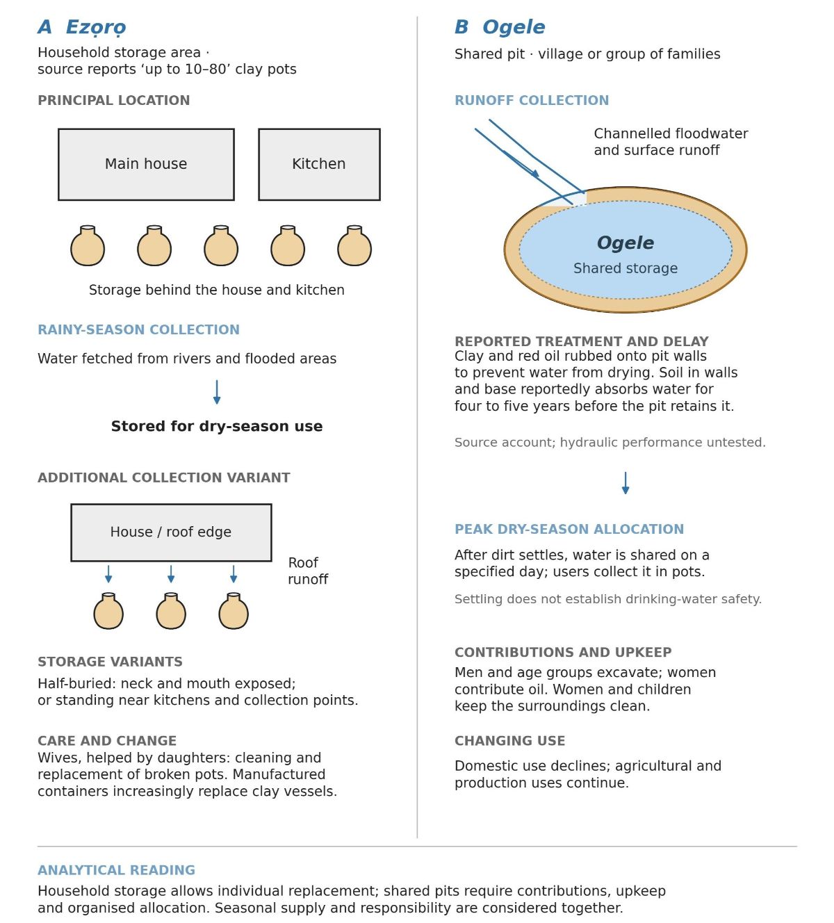
Uzuegbu (2020, p. 12) interprets these practices as responses to water scarcity through environmental modification. His discussion links locally produced iron tools specifically to the digging of wells and cisterns. In this interpretation, the reported retention delay suggests an investment spanning several seasonal cycles. It raises a question about sustaining collective contributions before the full benefit is realised, rather than providing a verified hydraulic explanation.
The arrangements linked physical provision to different responsibilities. Household pots placed storage near domestic activities, allowing individual replacement. Shared pits required contributions to construction and treatment, ongoing upkeep, and organised allocation. The sharing day made access part of the system’s operation. Uzuegbu (2020, pp. 5–6) also records change: manufactured containers increasingly replaced clay pots, while Ogele continued to serve agricultural and production uses as domestic use declined.
The design proposition is to provide cleaning and individual replacement in household storage, and agreed contributions, upkeep, and allocation in shared storage. Contemporary proposals should link collection routes and storage locations to maintenance resources and distribution arrangements. Users should negotiate responsibilities rather than inherit them from the precedent’s gender divisions. The account supports this organisational lesson; lining performance, storage capacity, and water safety require separate assessment. Reported settling alone does not establish suitability for drinking.
Mgbom, Afikpo: Shared spaces, terrain and routes
Nsude (1987, pp. 241, 244) places Afikpo within the uplands and escarpments of eastern Igboland. He describes the village group’s layout as shaped by its geographical and social history, noting that individual villages retained recognisable patterns of compounds and commons. His account refers to Ottenberg’s anthropological work in the 1960s; the Mgbom map is reproduced after Ottenberg (1971). It is therefore treated here as historical documentation.
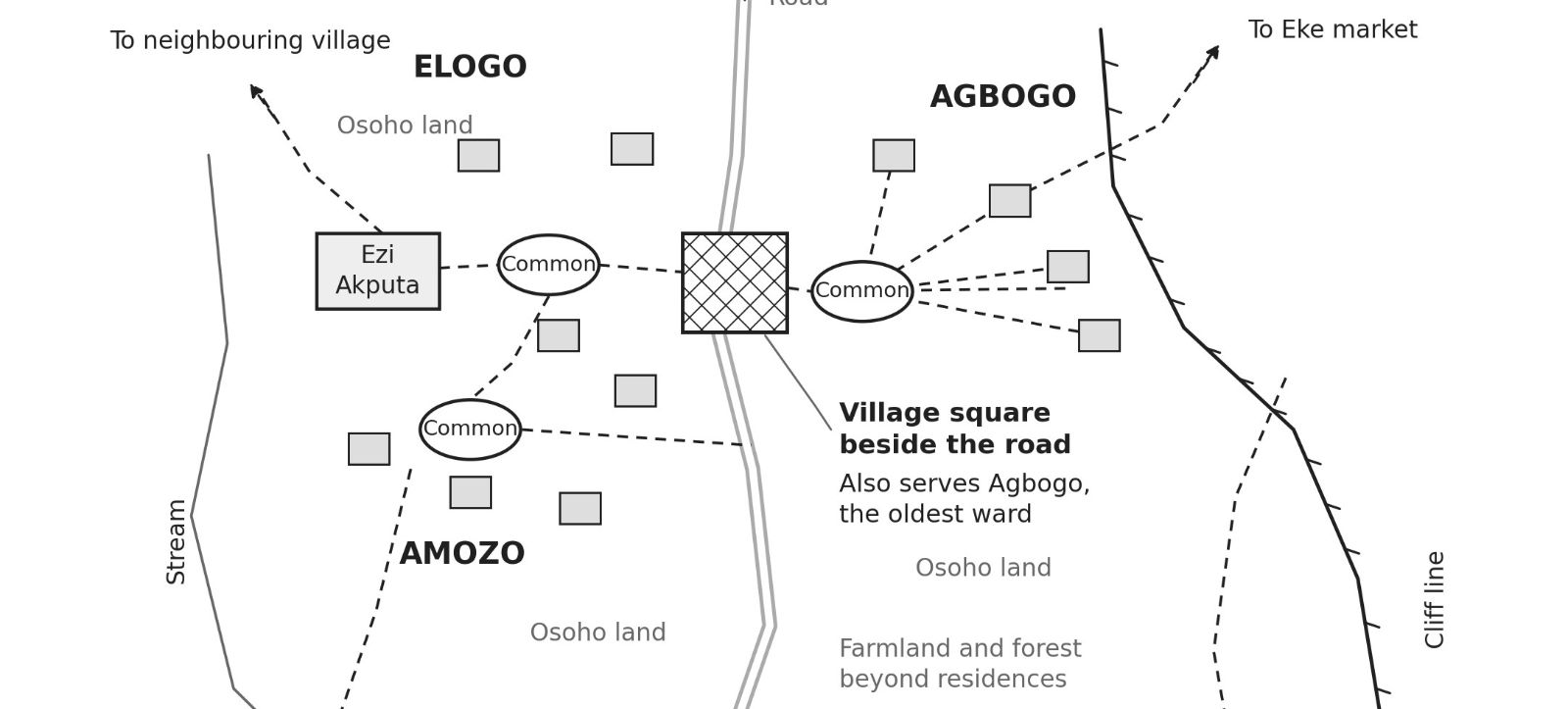
Nsude (1987, pp. 244–245) identifies three principal wards in Mgbom—Agbogo, Elogo and Amozo—comprising twenty-two compounds. The centrally located village square also served as Agbogo’s common, the oldest ward. It accommodated major rituals and discussions of village affairs, while other wards maintained their own commons. On the map, the square lies beside the road near Elogo’s common, with Agbogo’s compounds extending eastwards towards the cliff.
This overlap between ward and village functions has a social explanation. In his preceding Nsukka example, Nsude (1987, p. 241) explicitly associates the eldest ward’s claims to the village square with its use as that ward’s common. His identification of Agbogo as Mgbom’s oldest ward supports reading seniority as relevant to the arrangement. However, it does not specify the full rules governing access or the resolution of competing claims.
The connection to the surrounding land is particularly clear at Ezi Akputa, shown alongside Elogo’s common in Nsude’s (1987, pp. 245, 255–256) settlement and compound drawings. Nsude (1987, p. 255) describes its mud, wood and bamboo fence as screening the compound from the ward common. Its rear opens onto oso-ho, a bush groveland used for expansion, gardens, waste disposal, latrines and pottery firing. Paths extend from this area to farmland and a stream. The compound thus links a more publicly accessible frontage with a rear territory that supports domestic and productive activities.

Read together, the map and description link gathering places to residential claims, everyday work and the surrounding land. Streams, cliffs and routes to farms, markets, neighbouring villages and a burial ground provide the wider setting. Their presence identifies relevant questions about drainage and seasonal movement, although the source does not document gradients or crossing conditions.
The design proposition is to accommodate local and wider collective uses while recognising established claims and responsibilities. A space serving a larger population may remain closely associated with a particular residential group. Contemporary proposals should therefore examine who holds claims, who uses the space and who maintains it before extending its role. Negotiation is proposed here as a contemporary process, not as Mgbom’s historical mechanism. The Ezi Akputa account adds that routes between commons, compounds and productive land should be considered together, rather than treating the gathering space as an isolated amenity.
Comparative discussion: From case evidence to design propositions
The cases link environmental provision to specific activities, meanings and responsibilities. Table 2 distinguishes their reported basis from the design propositions developed here. The comparison addresses different environmental relationships and organisational scales, supported by uneven documentation.
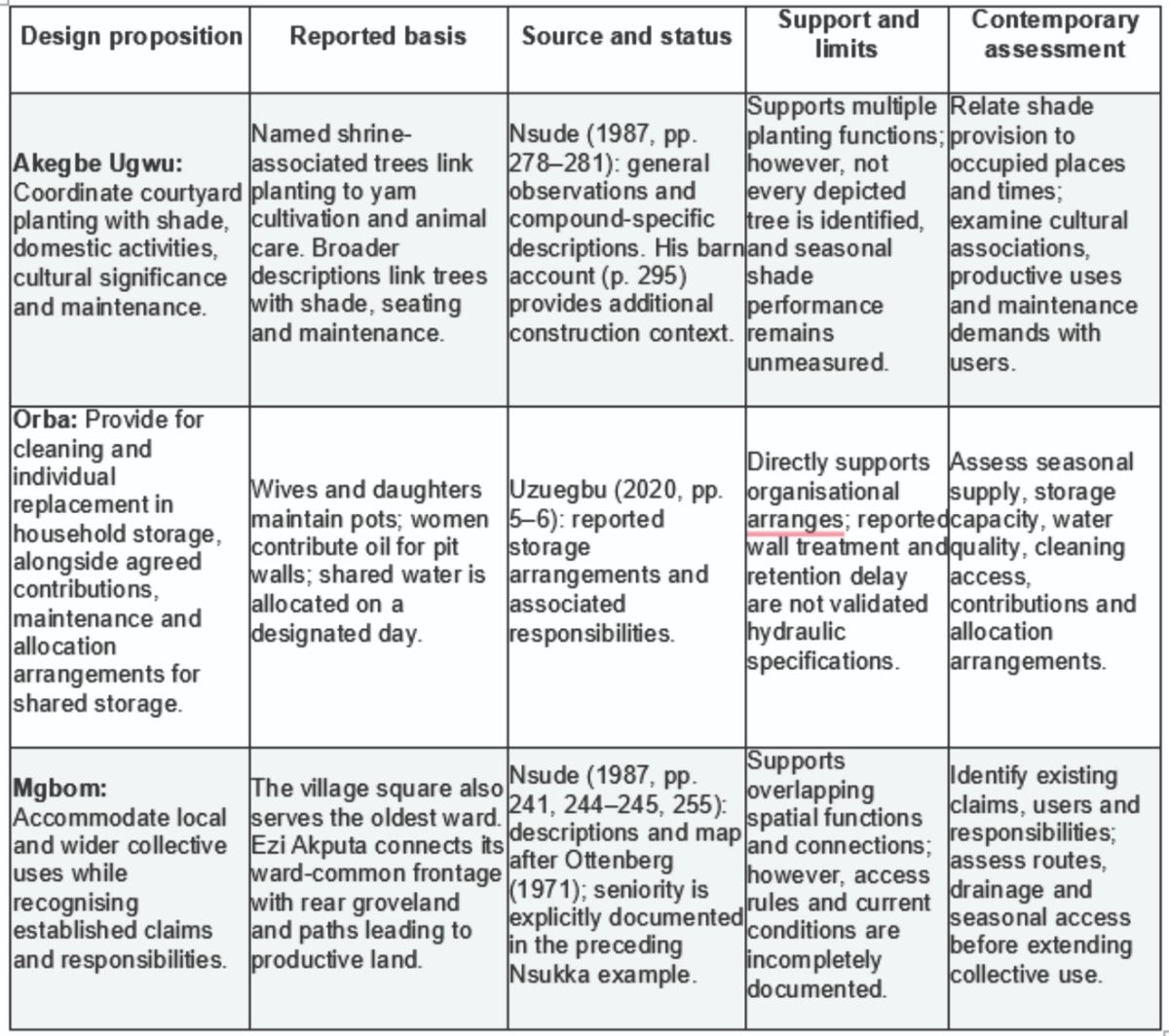
Comparison shows that continuing care takes different forms. Courtyard planting combines shade with domestic, ritual and productive functions, while creating recurring demands for clearance and pruning. Household pots allow individual components to be replaced, whereas shared pits require contributions and coordinated distribution. A ward common serving the wider village brings local claims into contact with broader use. The design implication is therefore to match physical provision to the scale and duration of the responsibilities required to sustain it.
These distinctions also shape how lessons travel. Tree selection cannot be separated from users’ associations with plants; a storage facility cannot be assessed by capacity alone; and a larger gathering role cannot be assumed to erase existing claims. Contemporary application requires examining these relationships with present users. Negotiation is proposed as part of that process, rather than being asserted as a historical practice common to all three cases.
Nassauer’s (1995) account of culture and landscape structure, together with Spirn’s (2019) concept of landscape literacy, support this reading of physical settings alongside social practices. Landscape-as-Teacher names the translation of specific arrangements into design propositions, thereby making their evidential basis and conditions of application explicit.
Conclusion
The three cases offer specific lessons for landscape design. Akegbe Ugwu links courtyard planting to domestic activities, ritual observance and animal care, and considers these links alongside broader accounts of shade and maintenance. Orba connects seasonal storage with individual replacement, collective contributions and scheduled allocation. Mgbom shows how village-wide gathering can overlap with a ward’s established role, while routes link communal space, compounds and productive land.
The comparison supports coordinating planting with shade, activities, cultural meaning and upkeep; providing for cleaning and replacement in household storage and for agreed responsibilities in shared storage; and accommodating wider collective use while recognising existing local claims. Continuing care varies across these arrangements, from recurring household tasks to coordinated infrastructure management and responsibilities spanning residential groups.
Landscape-as-Teacher makes the transition from published account to design proposition explicit. These cases contribute by describing the specific connections between physical provision and everyday life. Contemporary application requires examining those connections with current users, assessing environmental performance, and adapting responsibilities and access to current conditions.
References
Nassauer, J.I. (1995) ‘Culture and changing landscape structure’, Landscape Ecology, 10(4), pp. 229–237. https://doi.org/10.1007/BF00129257.
Nsude, G.C. (1987) The traditional architecture of the Igbo of Nigeria. PhD thesis. Thames Polytechnic. Available at: https://gala.gre.ac.uk/id/eprint/8750/ (Accessed: 21 October 2026).
Olgyay, V. (1963) Design with climate: Bioclimatic approach to architectural regionalism. Princeton, NJ: Princeton University Press.
Oluwarotimi, Y.I. (2026) Pathway to passive design for energy-efficient residential buildings in Nigeria (blending tradition and modernity). Doctoral thesis. Technische Universität Darmstadt. https://doi.org/10.26083/tuda-7999.
Ottenberg, S. (1971) Leadership and authority in an African society: The Afikpo village-group. Seattle: University of Washington Press.
Rapoport, A. (1969) House form and culture. Englewood Cliffs, NJ: Prentice-Hall.
Spirn, A.W. (2019) ‘Landscape literacy and design for ecological democracy: The nature of Mill Creek, West Philadelphia’, in Ernstson, H. and Sörlin, S. (eds.) Grounding urban natures: Histories and futures of urban ecologies. Cambridge, MA: MIT Press, pp. 109–136. https://doi.org/10.7551/mitpress/11600.003.0008.
Uzuegbu, J.O. (2020) ‘Further archaeological investigation of iron smelting sites in Orba, Enugu State, Nigeria’, Ikenga: International Journal of Institute of African Studies, 21(4), pp. 1–14. Available at: https://ikengajournal.unn.edu.ng/wp-content/uploads/2020/08/IKENGA-VOLUME-21-No.-4.pdf (Accessed: 21 October 2026).