Vernacular Landscape: Aesthetic Pattern or Learning Resource?
ABout the Author/s



Les paysages vernaculaires des montagnes de l’ouest de l’Iran sont souvent interprétés comme des modèles esthétiques destinés à inspirer la conception, réduisant les murs en pierre sèche, les structures en terrasses et les plantations indigènes à de simples références décoratives plutôt qu’à des savoirs fonctionnels. Cet article examine si ces paysages constituent un patrimoine esthétique ou une ressource active d’apprentissage pour la conception. À travers une revue de la littérature éclairée par des spécialistes du paysage, il réexamine les savoirs environnementaux adaptés aux climats montagnards froids et arides. Les résultats indiquent que ces paysages intègrent des solutions d’adaptation climatique affinées au fil des générations. Les murs en pierre sèche contribuent au drainage perméable en régulant le ruissellement et peuvent réduire les risques de gel dans la zone racinaire. Les structures en terrasses répondent à l’érosion des sols et à l’écoulement de l’eau sur les pentes raides. Les espèces indigènes, notamment le chêne (Quercus spp.), le pistachier sauvage (Pistacia atlantica) et le thym (Thymus spp.), présentent une tolérance à la sécheresse et au gel au cours de saisons différentes. Leur répartition irrégulière et groupée au sein des substrats rocheux s'inscrit conceptuellement dans le principe de « plantation en matrice » propre à la conception paysagère contemporaine.Ces résultats ont contribué à la conception d’un parc urbain structuré selon quatre dimensions à Sanandaj. La conception proposée devrait consommer moins d’eau d’irrigation que les parcs conventionnels tout en préservant l’identité culturelle régionale, bien que cette économie n’ait pas été quantifiée. L’étude conclut que l’apprentissage des paysages vernaculaires exige de passer de l’imitation visuelle à l’interprétation fonctionnelle.
Vernacular landscapes in the mountains of western Iran are often treated as aesthetic patterns for design inspiration, reducing dry-stone walls, terraced structures, and native planting to decorative references rather than functional knowledge. This article examines whether vernacular landscapes constitute aesthetic heritage or an active learning resource for design. Drawing on a literature review informed by landscape specialists, it revisits environmental knowledge adapted to cold, arid mountain climates. The findings indicate that these landscapes embody climate-adaptive solutions refined over generations. Dry-stone walls contribute to permeable drainage by regulating runoff and may reduce root-zone frost damage. Terraced structures address soil erosion and water movement on steep slopes. Native species, including oak (Quercus spp.), Persian turpentine tree (Pistacia atlantica), and thyme (Thymus spp.), tolerate both drought and frost across seasons. Their irregular, clustered distribution among rocky substrates is conceptually consistent with “matrix planting” in contemporary design. These findings informed a four-layer urban park design for Sanandaj, Iran. The proposed design is expected to use less irrigation water than conventional parks while retaining regional cultural identity, although this saving has not been quantified. The study concludes that learning from vernacular landscapes requires a shift from visual imitation to functional interpretation.
Introduction
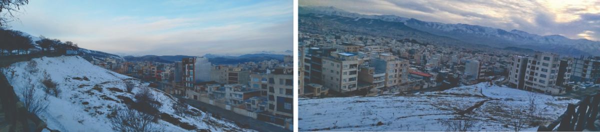
Sanandaj, the provincial capital of Kurdistan in western Iran, has experienced considerable population growth and urban expansion in recent decades, increasing demand for public green space. At the same time, the city lies within a cold, arid mountain climate, where recurrent drought and diminishing water resources place serious constraints on urban landscape design. Nevertheless, the author’s field observations of existing green spaces in Sanandaj indicate that the prevailing design approach still relies largely on high-water-demand species, conventional irrigation, and industrial materials. This approach is neither fully compatible with the region’s hydrological conditions nor a clear reflection of its vernacular cultural identity. Urban development in Sanandaj’s landscape sector has therefore proceeded largely without systematic reference to the region’s indigenous knowledge.
By contrast, vernacular landscaping patterns remain active in the region's peripheral and rural areas, along the Zagros slopes surrounding Sanandaj. These patterns include mortarless dry-stone walls that manage runoff and erosion, terraced structures that convert steep slopes into cultivable surfaces, and native vegetation adapted to seasonal drought and frost. Although these patterns were not formally developed within xeriscaping frameworks an approach that emerged in Colorado during the 1980s to reduce landscape water use (Colorado WaterWise, 2004; Sovocool and Morgan, 2005) they serve similar functional purposes by reducing water consumption while maintaining landscape quality.
This study argues that transferring these vernacular patterns from rural and peripheral settings to urban park design can achieve two key objectives: reducing water consumption in line with the region’s climatic constraints and establishing cultural legibility in urban green space to foster an identity-based connection among residents. The central question is whether the region’s vernacular landscape is merely a heritage resource for visual reproduction or an active learning resource for applying xeriscape principles at the urban scale.
Research Setting: Sanandaj and the Vernacular Landscape of the Zagros
Sanandaj is located at a mean elevation of 1,450 to 1,550 metres above sea level in the central Zagros mountain range. According to the Köppen climate classification, the city has a cold, semi-arid climate, with relatively mild, Mediterranean-type summers. An analysis of meteorological data recorded in Sanandaj between 2015 and 2025 (Table 1) reveals two distinctive climatic characteristics. First, the city experiences a substantial seasonal temperature range of more than 22 °C, from a mean winter temperature of 2.6 °C to a mean summer temperature of 24.8 °C. Second, precipitation is unevenly distributed throughout the year. Seasonal calculations in Table 1 indicate that autumn and winter together account for 57.9 per cent of total annual precipitation, while summer, at only 8.1 per cent, is the city’s driest season. The calculated annual total is 509 mm.
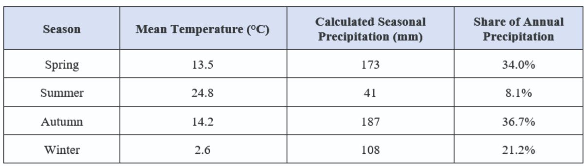
This dual climatic pattern, characterised by a long, severely dry summer and a long, cold winter with heavy snowfall, limits the effectiveness of conventional plant selection practices in urban green space design. Seasonal drought and frost also render conventional selection criteria inadequate, particularly when based solely on aesthetics or single-criterion xeriscaping guidelines. Moreover, the city’s steep topography intensifies challenges associated with spring snowmelt runoff, erosion, and flooding. Conventional artificial drainage systems offer only a partial solution and often entail high construction and maintenance costs.
Beyond Sanandaj, this climatic pattern is further complicated by two significant regional trends. First, precipitation is becoming increasingly irregular across western Iran (Fakour, Ustrnul and Wypych, 2025). Second, Zagros oak forests, a dominant component of the region’s natural vegetation, are gradually declining. This decline is partly associated with changes in precipitation patterns (Attarod et al., 2023; Akhtari, 2024). Together, these trends may weaken the hydrological and erosion-control functions of natural vegetation at the regional scale (Motaharfard et al., 2025).
This is why introducing vernacular landscape elements into Sanandaj’s urban parks is not merely a matter of taste or identity, but a necessity shaped by the city’s climatic conditions. In surrounding rural areas, native vegetation has adapted over time to drought and frost across seasons, while local structures manage runoff on sloping terrain. Sanandaj’s topography connects the city geographically and culturally with nearby rural settlements, including villages within the Uramanat cultural-ecological system. Unlike the expanding built-up areas, these settlements have retained their vernacular landscaping patterns, including dry-stone walls, terraced structures, and adapted vegetation cover, examined in the following section.
Methodology
This study employed three complementary approaches: a systematic literature review, field observation, and the Delphi method. Following a predefined protocol, the review covered international theoretical sources on xeriscaping and documentation of the Zagros vernacular landscape, providing the initial conceptual framework. Field observations were conducted in Hajij village, within the Uramanat cultural-ecological system on the border between Kurdistan and Kermanshah provinces, to document vernacular landscape elements directly. Like other Uramanat settlements, Hajij reflects architectural and landscape patterns shaped by the broader topographic and climatic conditions of both provinces. Observations of dry-stone walls, terraced structures, and natural vegetation cover formed the empirical basis for the analysis presented in the Findings section.
The Delphi method established expert consensus on the priority and effectiveness of the identified components through a structured, iterative process involving independent experts. Respondent anonymity helped reduce hierarchical influence within the panel (Linstone and Turoff, 1975). The panel comprised 15 interdisciplinary experts, most specialising in botany and water resource management, with additional expertise in landscape architecture, natural resources, architecture, and forestry. The panel participated in two consecutive rounds. In the first round, experts completed an open-ended questionnaire covering four domains: plant species selection, water management, materials, and aesthetic principles, with no predetermined response categories or directions. Qualitative thematic analysis and coding converted these responses into measurable indicators.
In the second round, these indicators were presented in a closed-ended questionnaire using a four-point importance scale. Frequency analysis identified the most frequently selected components, and final consensus reflected both response frequency and conceptual convergence among experts. Findings from the review, field observations, and the Delphi process together informed the framework for transferring indigenous knowledge into urban park design.
Findings: What the Vernacular Landscape Teaches
Field observations from Hajij village, together with expert consensus from the Delphi process, reveal four distinct functional patterns within the region’s vernacular landscape. Beyond their visual value, these patterns represent time-tested responses to the region’s climatic constraints.
Dry-Stone Walling: A Hidden System for Water Management
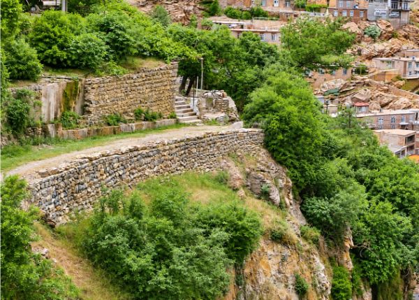
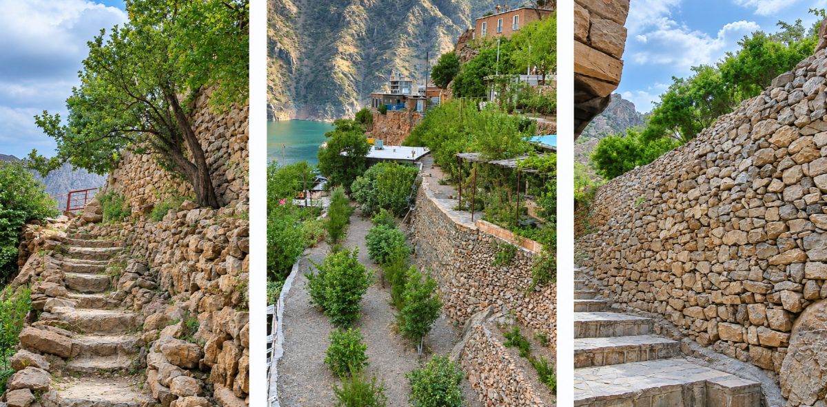
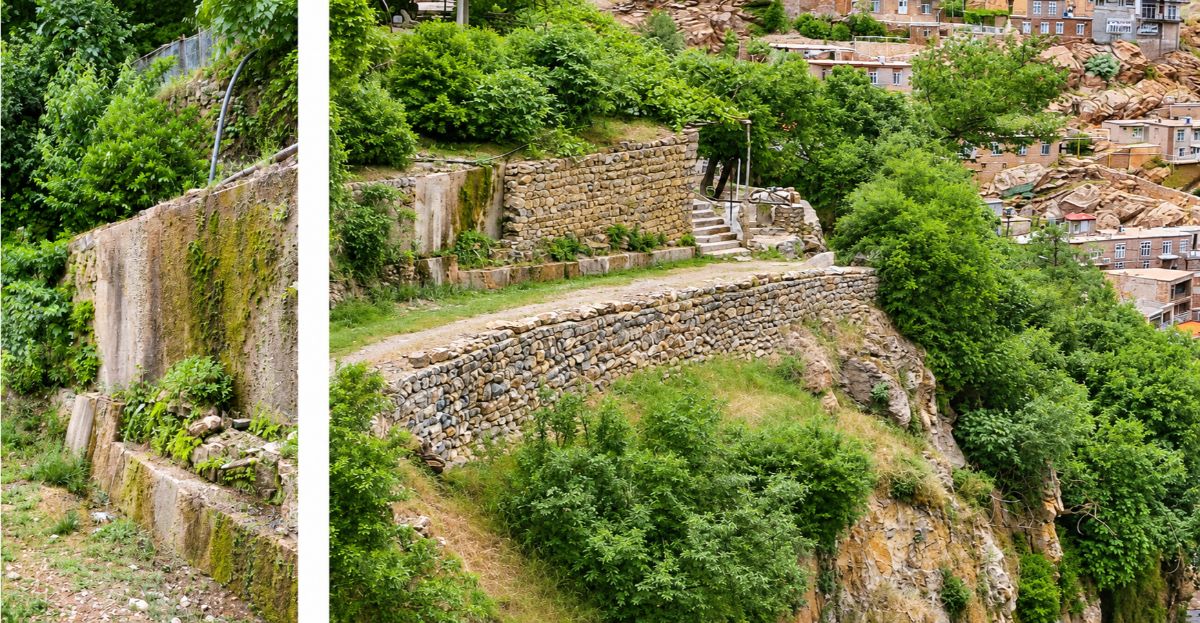
Dry-stone walling, the technique of constructing walls and terraces without mortar by precisely arranging local stones, may at first glance appear to be a purely visual element of Zagros vernacular architecture (Figure 1). However, examination of these structures reveals an important functional role. Their porous, mortar-free texture enables controlled infiltration and downward movement of water into the soil. Unlike conventional mortared walls, which may accumulate runoff behind the structure, dry-stone walls gradually direct water into the subsoil. In the Zagros region, where spring snowmelt runoff poses a major challenge for urban water management, this feature provides two key benefits: it regulates surface runoff and reduces localised root-zone frost damage associated with standing water near the soil surface. In this study, expert consensus ranked dry-stone walling among the highest-priority materials and techniques for xeriscape design in cold climates, reflecting not only its vernacular identity but also its observed and expert-assessed hydrological function.
Terraced Structure: Micro-Engineering of Slope and Erosion
Terraced gardens and cultivated slopes in the mountain villages of western Iran, particularly within the Uramanat cultural-ecological system (Figure 2), exemplify a form of soil and water micro-engineering developed over generations to address steep terrain and seasonal water scarcity (Talebnia and Ghaderian, 2024). By dividing continuous slopes into discrete horizontal surfaces, terraces reduce water-flow velocity and increase the time water remains in the soil. This water-retention function directly supports the logic of hydrozoning in the international xeriscaping literature, a principle involving the grouping of plants according to their shared water requirements, though typically formulated without reference to comparable vernacular precedents. (Figures 2 and 3).
Plants Tolerant of Two Seasonal Stresses
Conventional xeriscaping guidelines, largely developed in response to water scarcity in the hot, arid regions of the western United States, focus plant selection primarily on drought tolerance (Wade and Midcap, 2007). However, the native species observed in Hajij village experience two distinct seasonal stresses at different times of year: summer drought and winter frost. The final Delphi consensus identified dual tolerance to drought and frost across seasons as the most critical criterion for plant selection under the study area's climatic conditions (Table 2).
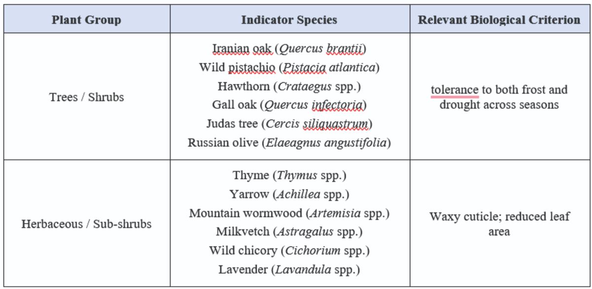
Selected examples from the tree and shrub group include Iranian oak, wild pistachio, hawthorn, and gall oak. Examples from the herbaceous and sub-shrub group include thyme, yarrow, mountain wormwood, and lavender. Across the assessed groups, the confirmed species were associated with adaptive traits such as deep root systems, reduced leaf area, and waxy cuticles. These traits may facilitate access to subsurface moisture, limit transpiration, and reduce water loss, respectively. The relatively high diversity of confirmed species, representing only part of the broader set examined during the Delphi process, suggests that these traits are not confined to one or two species within the assessed plant groups. Instead, they may represent a recurring feature of the region’s native vegetation in response to seasonal drought and frost stresses. Furthermore, the observed distribution of native vegetation in irregular clusters across rocky substrates may reduce competition for water and support plant persistence under water-limited conditions. This spatial pattern is conceptually consistent with the principle of “matrix planting” in contemporary naturalistic planting design.
Water, Without Water: Symbolic Representation in Vernacular Architecture
In the traditional architecture and landscape of Zagros villages, stone springs and water troughs, despite their minimal water use, strongly convey water's presence and significance to the observer. Their perceptual function is comparable to that of water-intensive features in contemporary design, but without imposing a high hydrological cost. This observation offers a practical response to a well-documented challenge in the xeriscaping literature: reduced water use is often perceived as a loss of the landscape’s perceptual and aesthetic quality, posing a significant barrier to the social acceptance of low water design (Yabiku, Casagrande and Farley-Metzger, 2008).
From Learning to Design: Application in Sanandaj's Urban Park
Introducing vernacular landscape knowledge into urban park design matters beyond preserving visual identity. This knowledge cannot be transferred through direct imitation. The elements observed in Hajij were developed for dispersed rural settlement and subsistence functions, rather than for the density and the recreational and social functions of an urban park. Transferring this knowledge into contemporary design therefore requires three steps: first, distinguishing symbolic and visual elements from those with direct ecological functions; second, abstracting the underlying principle of each vernacular element, independent of its outward form; and third, adapting these principles to the scale and operational requirements of a contemporary urban park.
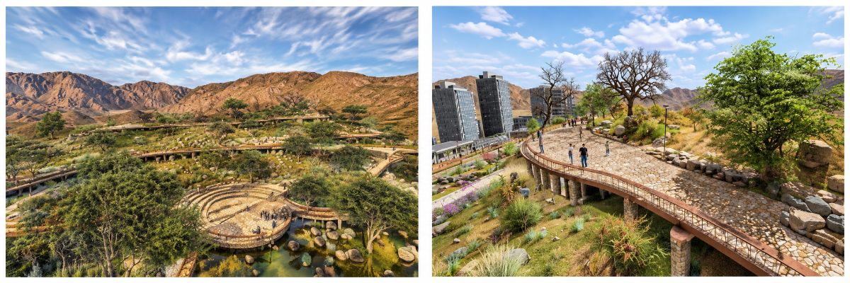
This three-step framework formed the basis of the strategic design for Sanandaj’s urban park, enabling a clear, traceable transfer across four design layers. At the ecological layer, tolerance to both frost and drought across seasons guided plant selection. The final Delphi consensus identified this criterion, supported by the species assessment in Table 2. The planting palette focused on native species, including Iranian oak (Quercus brantii), wild pistachio (Pistacia atlantica), and thyme (Thymus spp.). These were arranged in clustered patterns inspired by the principle of “matrix planting” (Rainer and West, 2015), rather than in regimented lines. The full planting palette is presented in Table 3.
At the hydrological layer, the principle of gradual drainage, derived from dry-stone walling, was translated into the park’s terraced retaining walls. Rather than using solid, impermeable concrete, these walls incorporate controlled joints and a stone drainage bed that facilitate the gradual infiltration of spring snowmelt runoff into the soil. At the morphological layer, rural slope-zoning logic was applied at two scales: at the macro scale, the park’s gardens were divided into horizontal terraces proportionate to the natural slope; at the micro scale, tree planting pits were designed as dry-stone rings, drawing on root-protective structures observed around mature trees in Hajij village. At the technological layer, symbolic water representation was applied through low water features, including reinterpretations of traditional stone water-trough forms in place of water-intensive features typical of contemporary design. These four layers were integrated into the proposed urban park scheme.
This four-part transfer was based on criteria established through response frequency, conceptual convergence, and overall agreement among experts, rather than on the designer’s judgement alone.
The proposed design is expected to use considerably less irrigation water than the conventional parks described in the Introduction, though this reduction has not been quantified. This expectation rests on three design decisions: first, the planting palette favours native species adapted to both summer drought and winter frost (Table 2); second, plants are grouped by water requirement so supplementary irrigation can be concentrated in specific zones and limited to periods of exceptional stress once established; and third, permeable dry-stone walls and drainage beds retain spring snowmelt on site, allowing it to infiltrate the root zone rather than leaving as runoff. While a field study of xeriscape conversion in Las Vegas reported savings of approximately 40 per cent (Sovocool and Morgan, 2005), that figure concerned existing landscapes in a different climate and serves as a contextual reference point rather than a prediction for Sanandaj. Quantifying precise savings would require site-specific evapotranspiration data, plant water-use coefficients, and metered irrigation records post-implementation.
Beyond Sanandaj, this methodological approach can also inform xeriscape design in urban areas throughout Kermanshah, Hamedan, and West Azerbaijan provinces.
Conclusion
This study investigated whether the vernacular landscape of the mountainous regions of western Iran should be understood merely as aesthetic heritage or as a practical learning resource for contemporary design. The findings indicate that these landscapes combine aesthetic value with ecological function. Dry-stone walls, terraced structures, and native vegetation serve functions interpreted through field observation and expert assessment. These functions become apparent through functional analysis rather than visual imitation alone.
The study's principal contribution is a three-step framework: identifying symbolic and functional elements, abstracting their underlying principles, and adapting these principles to the scale and requirements of an urban park.
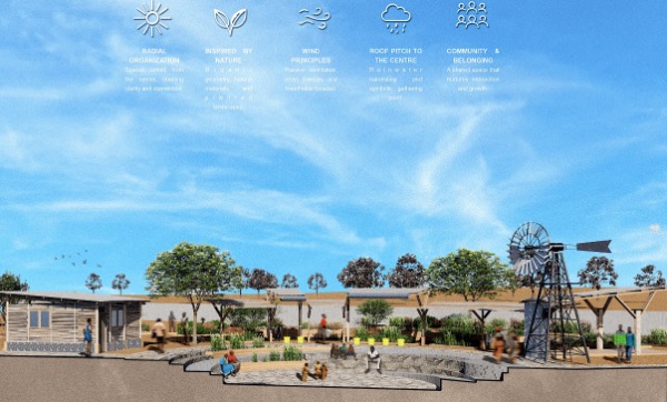
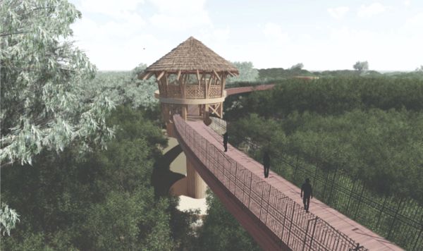
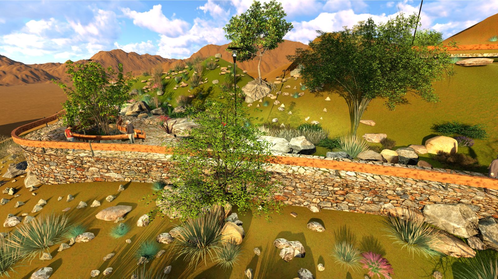
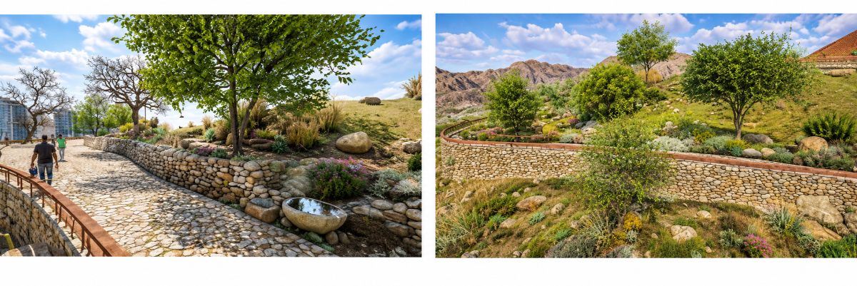
Applying this framework to Sanandaj provides preliminary evidence of its potential. The proposed design is expected to use less irrigation water than conventional parks while maintaining cultural legibility in the park landscape, although the extent of this saving has not yet been quantified. See the figures below, which illustrate the proposed design.
This study has several limitations. The fieldwork was confined to one village, and the design was applied to a single city. Post-implementation evaluation was not possible because the proposed park had not been constructed at the time of the study. Furthermore, although the Delphi consensus incorporated interdisciplinary perspectives, it cannot substitute for long-term field monitoring of native species in urban conditions. Future research should test the framework in suitable urban areas across Kermanshah, Hamedan, and West Azerbaijan provinces and evaluate its long-term ecological and social outcomes through post-implementation monitoring.
The findings suggest that landscape design in cold, arid climates need not treat aesthetic quality and water efficiency as mutually exclusive objectives. Vernacular practices in the Zagros have long addressed both aesthetic and water-management needs. The contemporary designer’s task is therefore not to reproduce vernacular forms directly, but to interpret their functions accurately and adapt them to the urban scale. This conclusion challenges the assumption within Iran’s landscape design profession that water conservation necessarily requires adopting design models developed for different climatic contexts. Effective strategies may instead be developed from the local environmental and cultural context in which the design is implemented.
References
Akhtari, M. (2024) ‘Theeffects of Quercus brantii Lindl. decline on forest structurein western Iranian forests’, Forestist, 74(1), pp. 45–56.
Attarod, P., Beiranvand, S.,Pypker, T.G., Bayramzadeh, V., Helali, J., Mashayekhi, Z. and Mariv, H.S.(2023) ‘Are precipitation characteristics and patterns impacting oak treedecline in the Zagros region of western Iran?’, Caspian Journal ofEnvironmental Sciences, 21(4), pp. 753–765.
Colorado WaterWise(2004) Welcome to xeriscaping. Denver: State Engineer Office WaterConservation Program.
Fakour, P., Ustrnul, Z. andWypych, A. (2025) ‘Risk assessment of extreme precipitation in northwest Iranin the light of changing climate’, International Journal of Climatology,45(2), article e8854.
Google Earth (2026) Foothillsof Mount Abidar, Sanandaj, 35°18′N, 46°59′E [Satellite image].Available at: https://earth.google.com/web/ (Accessed: 15 October2026).
Linstone, H.A. and Turoff, M.(eds) (1975) The Delphi method: Techniques and applications.Reading, MA: Addison-Wesley.
Motaharfard, E., Mahdavi, A.,Akhavan, R., Fallah, A., Omidipour, R. and Maxwell, S. (2025) ‘Tree growthresponses to climatic factors: Lessons from semi-arid Zagros oak forests,western Iran’, Iranian Journal of Forest and Poplar Research,16(5), pp. 99–114.
Rainer, T. and West, C.(2015) Planting in a post-wild world: Designing plant communities forresilient landscapes. Portland, OR: Timber Press.
Sovocool, K.A. and Morgan, M.(2005) Xeriscape conversion study: Final report. Las Vegas:Southern Nevada Water Authority.
Talebnia, P. and Ghaderian, E.(2024) ‘Documentary experiences of rural settlements in the cultural landscapeof Hawraman’, Journal of Cultural Heritage Management and SustainableDevelopment.
Wade, G.L. and Midcap, J.T.(2007) Xeriscape: A guide to developing a water-wise landscape.Athens, GA: University of Georgia Cooperative Extension.
Yabiku, S.T., Casagrande, D.G.and Farley-Metzger, E. (2008) ‘Preferences for landscape choice in aSouthwestern desert city’, Environment and Behavior, 40(3), pp.382–400.