
Historic Urban Landscape Framework: Reviving the Lost Historical Connections around Western Group of Temples, Khajuraho, Central India
ABout the Author/s


Les sites culturels, sacrés et patrimoniaux perdent de leur importance et se dégradent complètement en raison de l'accélération du changement climatique et des développements liés à l'économie. Ces sites patrimoniaux sont profondément marqués par une expansion urbaine intensifiée par l'activité humaine, perdant ainsi leur caractère sacré dans les paysages actuels. Sur les 85 temples sacrés de Khajuraho, en Inde centrale, 22 ont été classés au patrimoine mondial de l'UNESCO en 1986 pour leur érotisme, leur géométrie sacrée, leur cosmologie, leur sensualité et l'architecture ordonnée de style Nagara, construits entre le IXe et le XIe siècle par les rois de la dynastie Chandela. Ces temples constituent une formation et une institution uniques de l'esprit, de l'âme et du corps humains. L'étude révèle qu'avec l'augmentation des activités touristiques, l'urbanisation rapide et la déconnexion des habitants locaux par rapport à ces temples, le patrimoine et les valeurs sacrées du site se sont dégradés. Les aménagements actuels du site à l'intérieur et autour des temples et du lac Shiv Sagar, menés par le gouvernement de l'État et l'Archaeological Survey of India (ASI), ne constituent qu'un traitement esthétique visant à accroître le tourisme axé sur des stratégies lucratives, échouant ainsi à faire revivre son cadre culturel et historique. L'objectif de la présente étude est de rétablir les liens perdus et endommagés en utilisant le cadre du paysage urbain historique (HUL) recommandé par l'UNESCO en 2011, notamment la gestion des zones patrimoniales avec une gestion globale du paysage urbain autour du lac Shiv Sagar et du groupe de temples occidental. L'étude conclut que, dans le cadre de la gestion de ces sites patrimoniaux, le cadre HUL s'avère pertinent pour redonner vie au patrimoine perdu ainsi qu'aux liens socioculturels et écologiques entre le lac Shiv Sagar, ses temples, la population locale et les touristes. Elle recommande d'intégrer les concepts HUL à l'aide de techniques telles que les évaluations d'impact sur le patrimoine, le zonage patrimonial et l'aménagement du territoire respectueux du patrimoine, afin de repenser ces sites ancrés dans la culture et de les préserver pour les générations futures.
Cultural, sacred, and heritage sites are losing their importance and being completely degraded due to accelerating climate change and economy-driven developments. Such heritage sites are profoundly dominated by human-driven urban expansion, losing their sanctity in contemporary landscapes. Out of 85 sacred temples in Khajuraho, Central India, 22 were declared UNESCO World Heritage Sites in 1986 for their eroticism, sacred geometry, cosmology, sensuality, and orderly Nagara-style temple architecture, built between the 9th and 11th centuries by kings of the Chandela dynasty. These temples are a unique formation and institution of the human mind, soul, and body. The study reveals that, with increasing tourism activity, rapid urbanisation, and the disconnection of locals from these temples, the site's heritage and sacred values have declined. The present site developments in and around the temples and Shiv Sagar Lake by the state government and the Archaeological Survey of India (ASI) are only an aesthetic treatment aimed at increasing tourism, focused on money-making strategies, and hence fail to revive its cultural and historical setting. The aim of the present study is to repair lost and damaged connections using the Historical Urban Landscape (HUL) framework recommended by UNESCO in 2011, including the management of heritage zones and comprehensive urban landscape management around Shiv Sagar Lake and the western group of temples. The study concludes that, when dealing with such heritage sites, the HUL framework is meaningful for revitalising the lost past heritage and the socio-cultural and ecological connections of Shiv Sagar Lake and temples with locals and tourists. The study recommends integrating HUL concepts, aided by techniques such as heritage impact assessments, heritage zoning, and heritage-sensitive land-use planning, to reimagine these culturally rooted sites and conserve them for future generations. Keywords: Economy-generated developments, Historical urban landscape framework, Cosmology, Comprehensive urban landscape, Socio-cultural and ecological connections.
Introduction
Cultural wealth is essential to any process of urban development (Al-hagla, 2010; Guzmán et al., 2017; Šćitaroci et al., 2019). Its relevance rises dramatically in historical regions, where cultural tourism is stimulated by the richness of its cultural assets (Al-hagla, 2010; Guzmán et al.,2017). This cultural wealth, religious practices, and memories of a place held by its inhabitants shaped and sculpted the dynamic atmosphere of urban heritage and its built environment (Cohen, 2010; Dhingra, 2014; Dhingra et al.,2016; Guzmán et al., 2017; Pecherskaya, 2018). Urban development and heritage discourses have deepened cities' challenges in taking into account their historic built environment in the context of sustainable urban development (Haumann et al., 2020; Tweed & Sutherland, 2007). Considering the contemporary relevance of the historical built environment, expeditious urban expansions in India and China have added further dimensions to these discourses.
(Haumann et al., 2020). In 2011, UNESCO initiated the HUL approach to clarify these expressions in the context of the uncontrolled human-intensified landscapes (Tweed & Sutherland, 2007). This approach transforms fragmented urban areas and their degraded historical settings into revived urban heritage and resilient urban environments by integrating heritage into urban design, environmental sustainability, and socioeconomic developments. (Haumann et al., 2020; NIUA 2022; Sharma & Aulakh, 2023; Tweed & Sutherland, 2017). India has witnessed the evolution of towns and cities, indulged in complex layers of cultural and religious diversity, which was further shaped by social and political factors (Sharma & Aulakh, 2023; Dhingra, 2014; Dhingra et al., 2016; Tweed & Sutherland, 2017), and has influenced urban planning and community interactions in significant ways. The multicultural and multifaceted HUL of India have faced several challenges while preserving their tangible and intangible heritage (Sharma & Aulakh, 2023; NIUA, 2022; Punja, 2010; Singh, 2021; Srivastava, 2018), and frequently disappeared due to an increase in population, unsuitable international tourism practices, and unregulated incursion of urban infrastructures (Sharma& Aulakh, 2023; NIUA, 2022).
In the cities of Ajmer and Pushkar in Rajasthan, the HUL framework was implemented through the Inclusive Heritage-based City Development Program (IHCDP) in order to reduce and manage uneven urban growth, encroachments, erroneous waste and sewage treatment, traffic congestion, and parking management (Sharma & Aulakh, 2023; NIUA, 2022). The program successfully adapts abandoned spaces to display local arts and cultural performances, promotes community interaction, maps the city's tangible and intangible legacy, and raises awareness (NIUA, 2022; Sharma & Aulakh, 2023). In the city of Gwalior, the HUL program has also contributed to increasing empowerment in recognising local needs, participatory methods for inventorying and valuing heritage assets, and governance systems for inclusive urban redevelopment (Singh, 2025).
With an emphasis on community-based regeneration rather than just tourism, the government's development plans for the city of Alwar, Rajasthan, incorporate the traditional residential culture of mohallas and chowks, along with their rich legacy, through the framework of HUL. It further secures long-term environmental and socioeconomic sustainability for such historic villages (Dhingra et al., 2016 & Dhingra, 2014).
Khajuraho's urban landscapes were influenced by several development plans under the Madhya Pradesh Nagar Tatha Gram Nivesh Adhiniyam 1973 Act from 1975 to 2031, which unfortunately eliminated the city's distinctive cosmological sacred geometry, socio-cultural heritage, and ecological values. As a result of concentrating exclusively on tourism management activities and economy-generated developments, these values have diminished and evaporated over time. This has also caused the locals to lose their deep-rooted, sacred ties to Khajuraho's sanctity, leading them to rely primarily on tourism revenue. By understanding similar Indian cases using the HUL framework, the study aims to reconnect its lost socio-cultural and ecological connections by integrating heritage zoning and comprehensive urban landscape planning along the edges of Shiv Sagar Lake and around the temple premises.
Khajuraho from Landscapes of Intimacy, Divinity to Spirituality
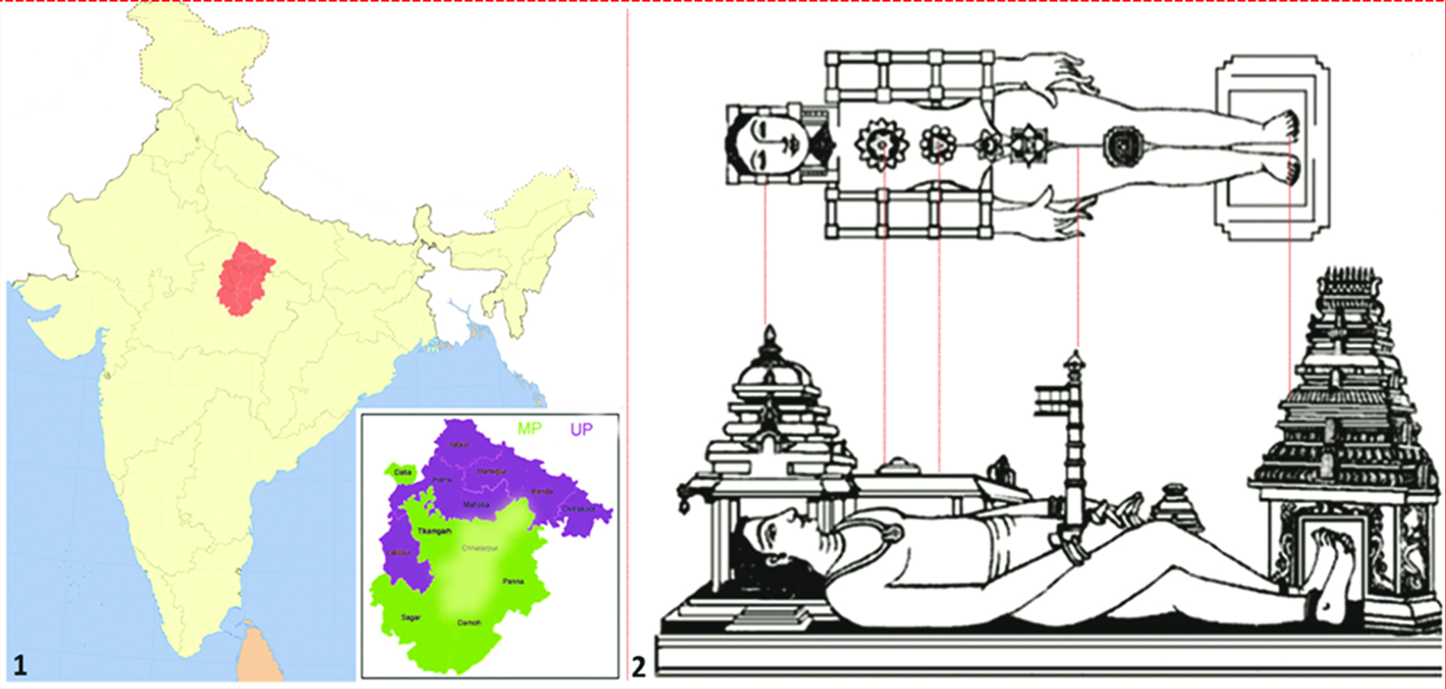
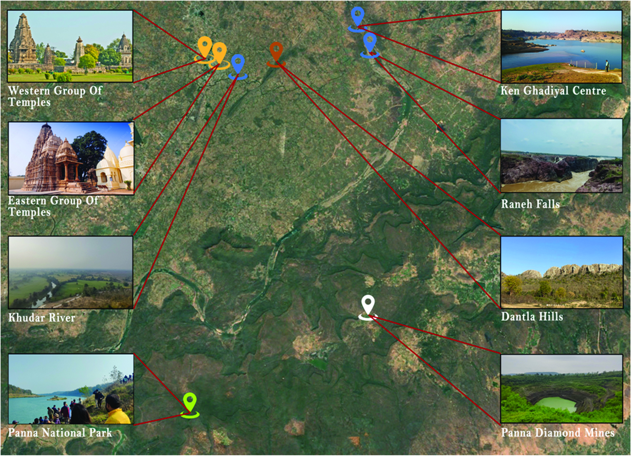
Khajuraho is the land of Kama Sutra, where each rock and stone has been dedicated to spiritual love of the divine universe and natural landscapes of Vindhya hills, rocks, rivers, falls, lakes, and dense forests in Chhatarpur district of Bundelkhand region, Central India (Lingis, 1979 & Punja, 2010). Khajuraho is an outstanding epitome and fusion of magic, myth, and nature, expressing its sacred cosmological landscapes shaped by religious and scientific observations, cultural activities, and the geological formation of conspicuous natural landforms (Pati, 2011 & Orr, 2018; Stockholm et al., 1989). These metamorphic natural landforms and sculptures are transforming from lust to love, from love to devotion, from devotion to spirituality, and from spirituality to super-consciousness (Lingis, 1979; Punja, 2010 & Mumford, 2021). These natural settings of Khajuraho serve as a historical and communicative record, with ancient people's revelations and myths providing a backdrop for understanding the past as a mental institution (Singh & Rana, 2017; Singh, 2024; Agarwal, 1980). Figure 1 represents the location of Chhatarpur district in Bundelkhand region, also describing the temple Vastu astrology and their sacred geography as a cosmic man, also known as Purusha (cosmic man). The sacred geometry of the temples, formed by the Dantla Hills and Lavanya Hills and curated by the Khudar River, is shown in Figure 2.

Natural Landscapes
Hills and Rocks
Geological formations in Khajuraho have crafted a unique landscape of igneous rocks, rich in pure crystalline granite in shades of pink, red, and grey, as well as dolomite, often referred to as "The Grand Canyon of India" (Gupta et al., 2024). The oldest Vindhya hill range geographically divides Khajuraho into northern and southern parts. The most striking Dantla hill forms the eastern boundary, thought to serve as an entrance to the temples, and Lavanya hill forms the southeast boundary of the region (Singh, 2009; Singh & Rana, 2017).
Rivers, Waterfalls and Lakes
The Betwa River surrounds the area of Khajuraho on the west, the Yamuna River bounds it on the north, and the Ken River borders it on the east. The Khudar and Kutni rivers also nourish and enhance their sacred landscapes (Prakash, 2024). The gigantic canyon served as a canvas for the Ken River to carve a series of waterfalls, including Raneh, Prapat, Pandav, Chirapani, Brihaspati, and Bedhak. The topography of Khajuraho was shaped by cultural activities, resulting in the creation of lakes such as Shivsagar, Khajursagar, and Ramsagar in the vicinity of the temples (Singh & Prakash, 2021).
Forests and Gardens
Historically, Khajuraho was known for its dense forests of Khajoor trees, from which the town derived its name (Punja, 2010). Panna National Park, located in the Vindhyan Range, encompasses extensive mountainous terrain, deep valleys, and diamond mines (Verma, 2024). The Ken Gharial Sanctuary along the Ken River is part of Panna National Park, which consists of bamboo and mixed forests (Gupta et al., 2024). Sixteen Bundeli gardens exist in Rajnagar near Khajuraho, according to Sharma and Upadhya (2019). Figure 3 shows the regional landscapes of Khajuraho.
Cultural Landscapes
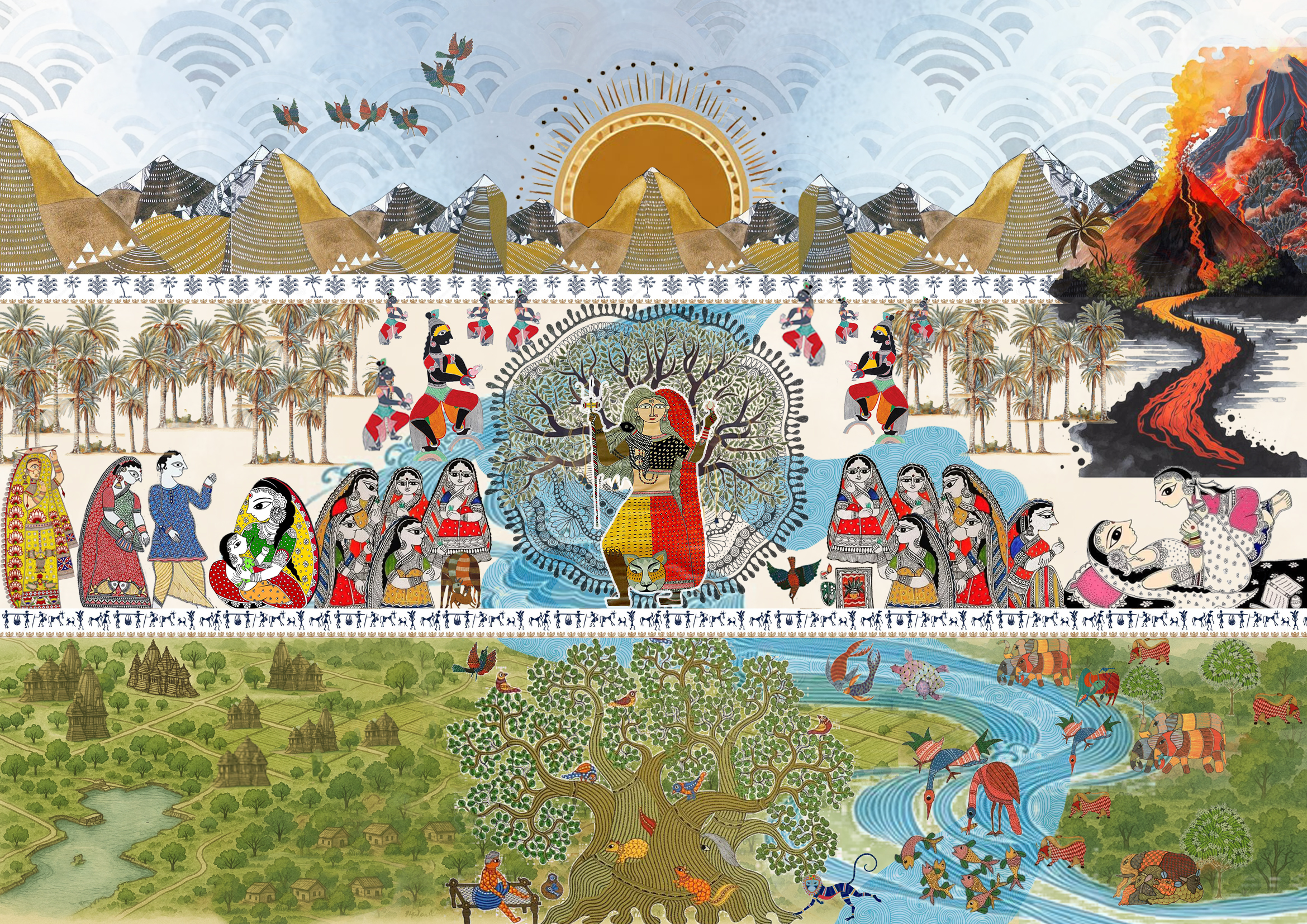
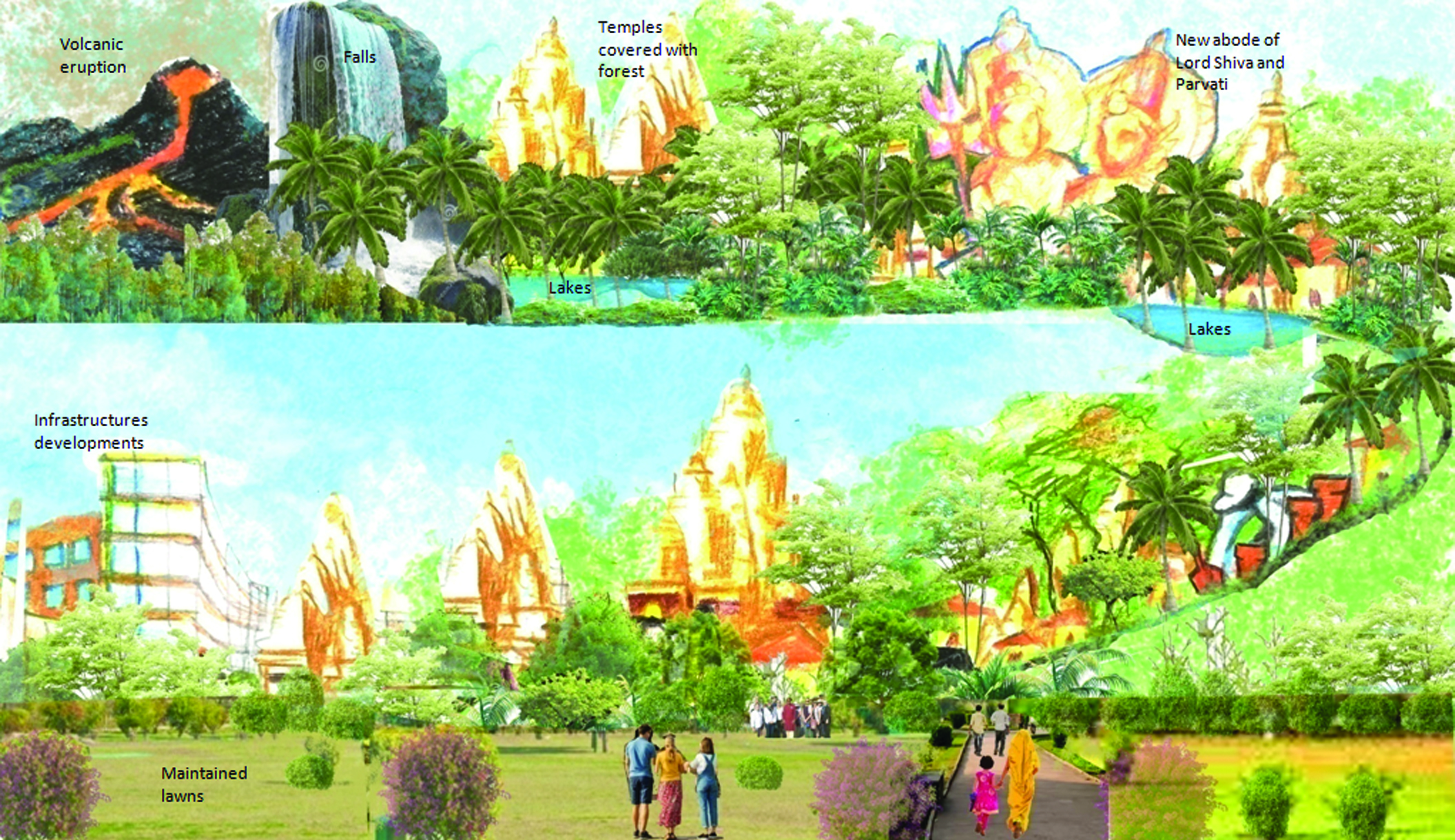
Over millions of years, rocks and water carved breathtaking cascades, reservoirs, and lakes (Gupta et al., 2024). These majestic landforms of rocks (Agni) and water (Jala) were further shaped by dense green forests (Bhoomi) and gorgeous gardens of date palms (khajoor), as well as forests of teak, palaash, and bamboo (Singh & Rana, 2017; Singh, 2024). This sacred landscape has become the abode for Lord Shiva and his beloved consort, Lord Parvati (Lingis, 1979; Punja, 2010 & Mumford, 2021). Intricate carvings and sculptures on these temples, socio-cultural, religious, and agricultural practices, teaching practices of the Kamasutra, divine dances and festivals cultivated this distinctive and extraordinary natural landscape of Khajuraho into a unique and outstanding cultural landscape (Singh & Rana, 2017; Singh, 2024). The rocks, water, and forest have witnessed these cultural celebrations for many ages, as reflected in the erotic carvings on these temples (Singh & Rana, 2017). Figure 4 shows the cultural landscape mapping of Khajuraho.
Khajuraho from Excavations to Restorations
Ibn Battuta visited the Khajuraho temples in 1355 CE, Abu Rihan al-Biruni in 1022 CE, and Xuanzang in 641 CE (Hioco & Poggi, 2017). The city seemed to have disappeared and was eventually covered by jungles. British engineer Captain T.S. Burt explored the region in 1838, and Alexander Cunningham rediscovered these temples in the 1850s and 1860s (Slaczka, 2012).
The state government has designated Khajuraho and its surroundings as a special region to manage its distinctive development issues due to a growth in international tourism (Gogoi, 2017; Shrivastava, 2018; Som et al., 2020). The Khajuraho development plan was first suggested in 1975 and became operative in 1978. It was replaced by the 1991 development plan, which aligned with the development vision until 2011 (Gogoi, 2017). Additionally, Khajuraho was recognised as a UNESCO World Heritage Site in 1986 for its exceptional architectural legacy and distinctive religious settings (Singh, 2009; Vijayakumar, 2017). However, the developments were less innovative than the 2011 Master Plan, focusing more on aesthetics but effectively managing crowds and boosting revenues. The establishment of the Khajuraho Dance Festival, as part of the 1975 master plan, was the second significant contribution to promoting international tourism (Som et al., 2020; Singh, 2021), which in turn led to the provision of infrastructure and urban development in and around the town. INTACH (Indian National Trust for Art, Culture, and Heritage, New Delhi) developed a comprehensive landscape plan, environmental cleanliness, and beautification for the World Heritage Sites of Khajuraho in 1998, proposing an integrated planning strategy for the next thirty years (Shrivastava, 2018). The Khajuraho Vikas Yojana 2011 includes several actions under 1973 Act, such as integrated heritage management and sustainable tourism development (Shrivastava, 2018). The community became a sought-after urban settlement due to the expansion of its infrastructure. All of these tourism-driven opportunities and government measures have helped the local villagers (Singh, 2021; Shrivastava, 2018).
The Archaeological Survey of India (ASI) enhanced the aesthetics of the local vicinity of the western and eastern temple groups without taking into account their historical significance and past connections (Singh 2021). Additionally, the Khajuraho master plan 2031, under the 1973 Act, was a contribution to providing urban infrastructure, commercial markets, new business models beyond tourism, and the development of roads, gardens, open spaces, water bodies, and parking areas, including battery-operated e-rickshaw parking. The glimpses of these provisions can be seen in the present scenario (Madhya Pradesh Gazette, 2019). Figure 5, showing Khajuraho from excavations to the present scenario.
Urban Developments and Expansions by the Archaeological Survey of India (ASI) and other Stakeholders
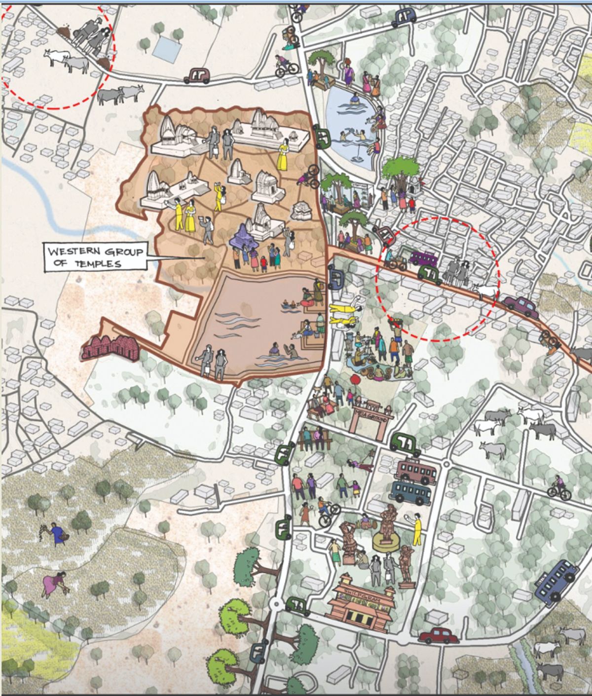
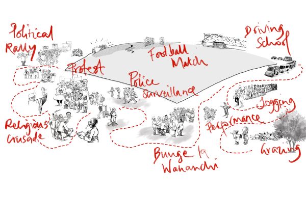
Despite being declared a World Heritage site and inclusion of integrated urban landscape management in the master plans of 1975, 1991, 2011, and 2031, the current conservation practices and efforts by ASI focus largely on aesthetics and beautification of the surroundings, neglecting the socio-cultural and spiritual knots that these temples once held with the local communities and villages (Singh 2021). Moreover, these temples were never curated in gardens as they are today, which is unjustifiable given their historically natural settings (Shrivastava, 2018; Som et al., 2020; Singh, 2021). Instead of restoring and conserving the historical settings, the urban interventions in Khajuraho are glamorising the present urban fabric by putting in infrastructure, fencing, lush green lawns bordered with hedges, random sandstone pathways, cafes, seating areas, selfie points and large parking areas (Som et al., 2020; Singh, 2021). Moreover, with the limited vision, the cumulative initiatives by government agencies are fragmenting monuments from their past historical landscapes. Figure 6 shows the activity mapping near the temple premises.
Disconnection from the Past to the Present
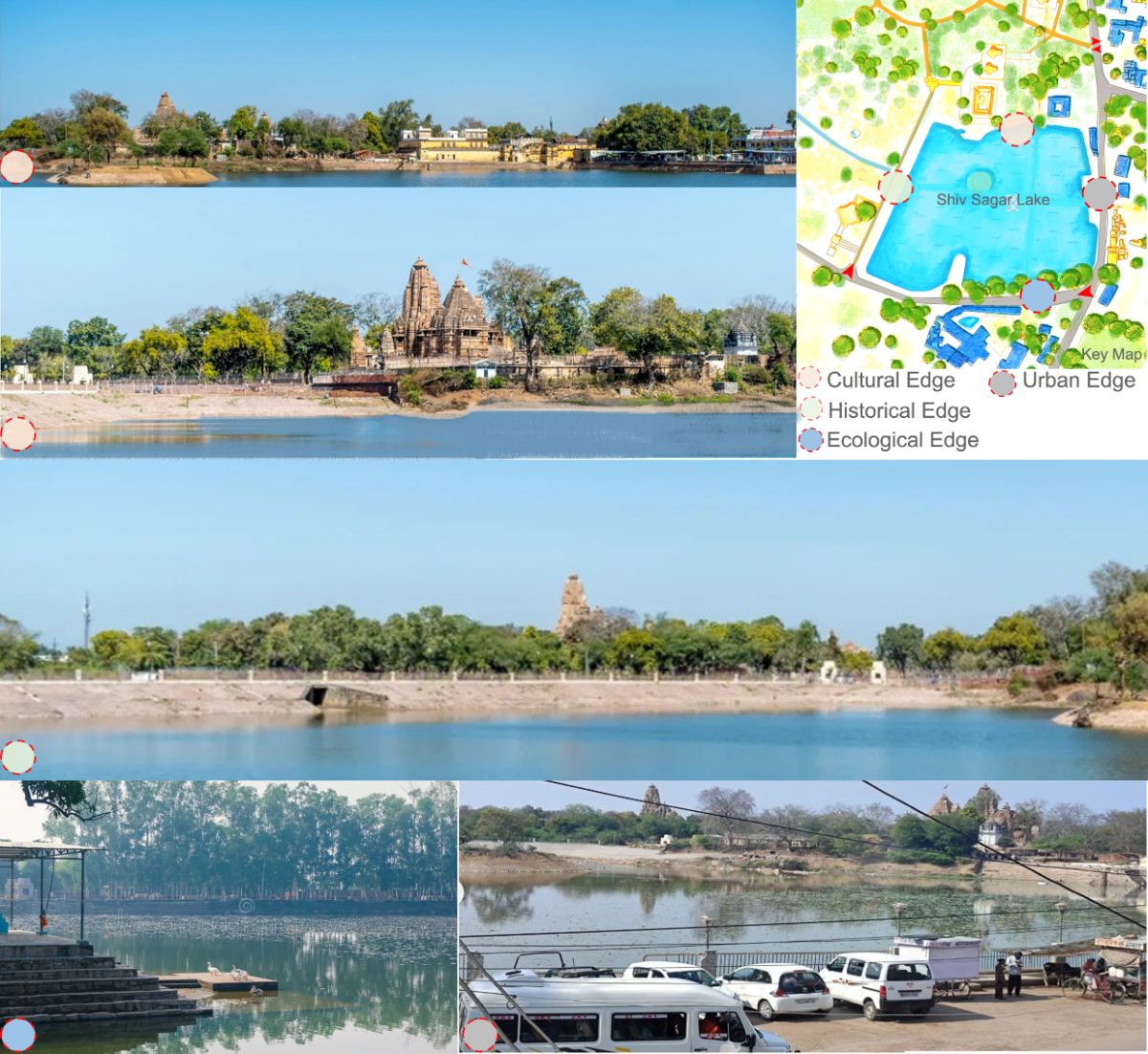
According to Singh (2021) and Shrivastava (2018), ASI and government agencies developed a series of plans and initiatives to accommodate both local and foreign visitors, control traffic, celebrate the temple architecture, and honour the arts and dance festivals. By addressing only tourism growth, these innovations are only partially successful. However, they are ineffective in the long term due to the lack of a comprehensive plan to restore and reconnect with local communities through lost socio-cultural and spiritual relationships (Shrivastava, 2018). Considering tourism is the primary source of revenue for the Khajuraho villagers, their affiliation with these sacred sites is confined only to their sources of wealth (Som et al., 2020). Additionally, Shiv Sagar Lake and other water bodies around the temple premises express the narrations of the Khajuraho people by embodying cultural, urban, historical, and ecological characteristics. However, their management by the authorities exemplifies only cosmetic treatment of their unthoughtful vision and superficial landscapes (Singh, 2021; Som et al., 2020). Figure 7, showing past and present traffic congestion and road movement at Khajuraho. Figure 8, showing the present conditions of Shiv Sagar Lake.

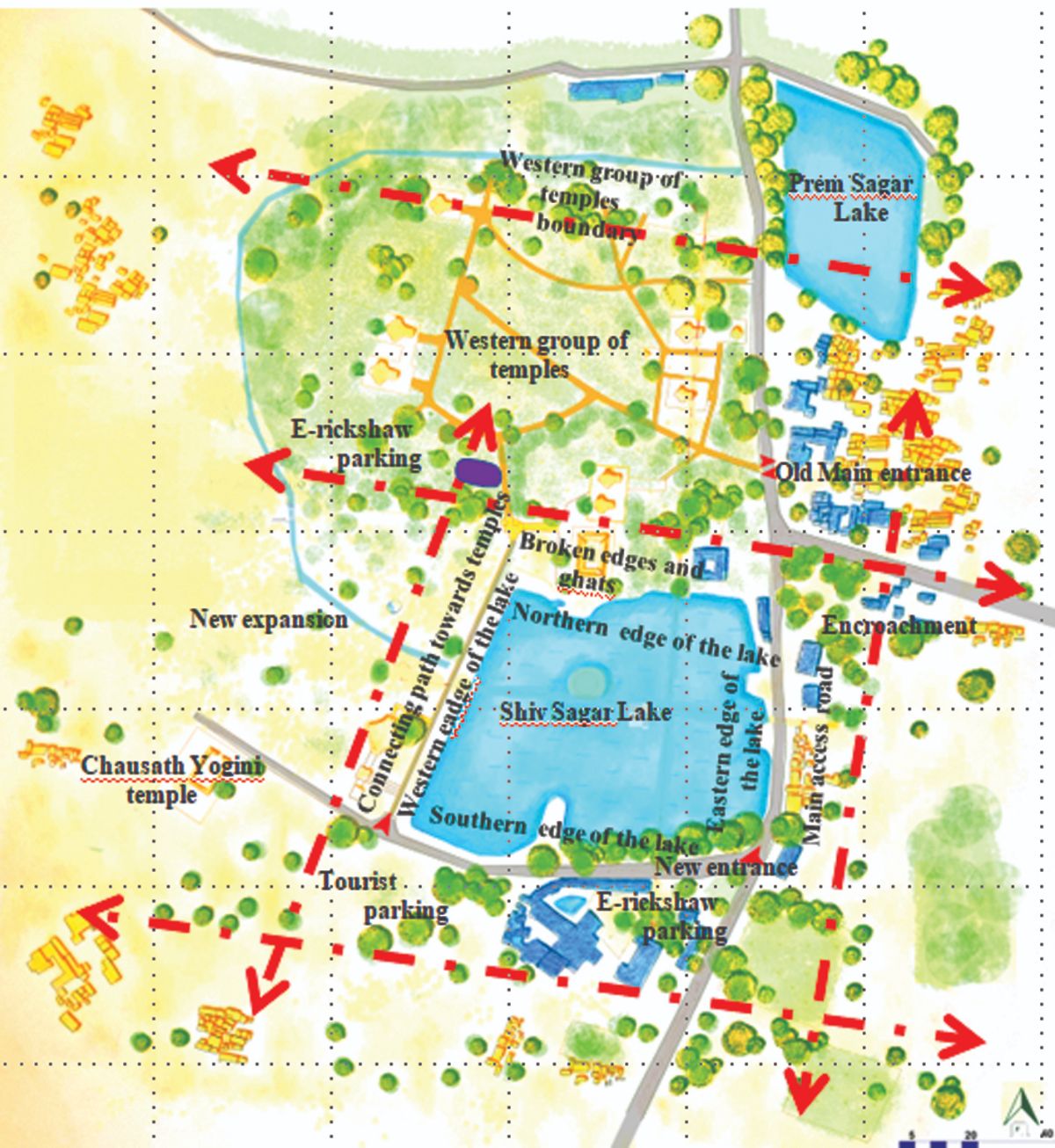
Delineation of the Study Region
The site boundaries have been delineated based on a deep understanding of the connections between the western group of temples, the edges of Shiv Sagar Lake, the main access road, and the newly constructed connections. Figure 9, showing the delineated study region.
Issues and Challenges
Recent developments around the Shiv Sagar Lake and adjacent to the temple premises have taken shape due to various international conferences and business summits organised from 2023 to 2025. However, due to the agencies' ignorant behaviour, there are still serious issues that need to be addressed.
1. The main entrance to the western group of temples has been relocated to the southern edge of the Shiv Sagar lake without using proper signage.
2. The edges of Shiv Sagar Lake have been in function without considering their historical references to provide only vehicular and pedestrian access, tourist parking areas at the main road in the east and south and e-rickshaw parking in the west.
3. The buffer areas have been intentionally ignored around all the edges of Shiv Sagar Lake just to get more spaces for the parking and vending activities.
4. A path connecting the Chausath Yogini Temple (shrines in India dedicated to the 64 Yoginis, embodying feminine divinity and Tantric cults) to the western group of temples has been provided at the western edge of Shiv Sagar Lake. A stream connecting to the lake has been overlooked, and the historical well of Bundela Hindu Garden has been left abandoned. Green lawns, selfie points, and seating along the lake edge have been provided as part of the new developments.
5. The cultural, recreational, ecological, and historical characteristics that the lake once possessed due to socio-cultural and religious activities performed along the edges have been fully ignored.
6. The socio-cultural and religious relationship of Shiv Sagar Lake and the western group of temples has not been considered due to the aestheticisation of the lake and temple premises.
7. The initiatives taken by the ASI and other government agencies have not taken into account or even visualised the management of heritage zoning around the lake and temple premises, implementation of ASI guidelines in providing infrastructure around the ruins, community spaces to restore the local crafts and sculptures, and the provision for performing cultural and religious rituals along the ghats at the lake. Figures 10 and 11 show the existing site scenarios.


Proposals
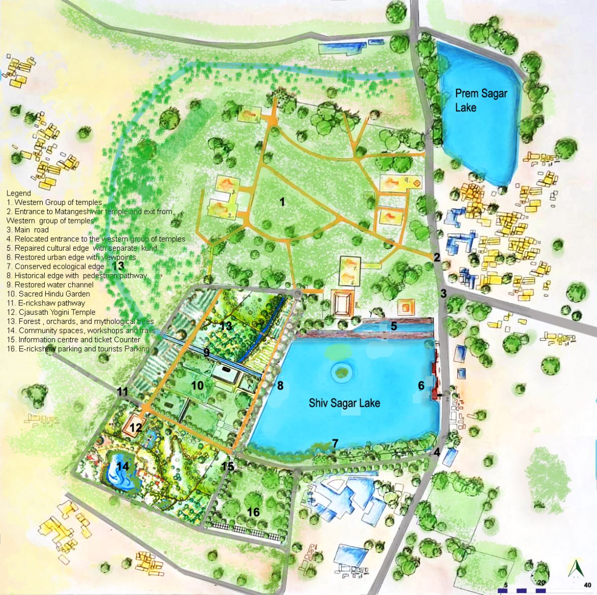
Following the proposals, the HUL framework and comprehensive urban design management have been used to address the above-mentioned issues.
Management of urban heritage
Heritage zones, such as areas around the Chausath Yogini temple and the northern and western edges of the lake, have been identified for their heritage values and have been provided with restored historical connections and gardens.
Integration of comprehensive urban landscape planning
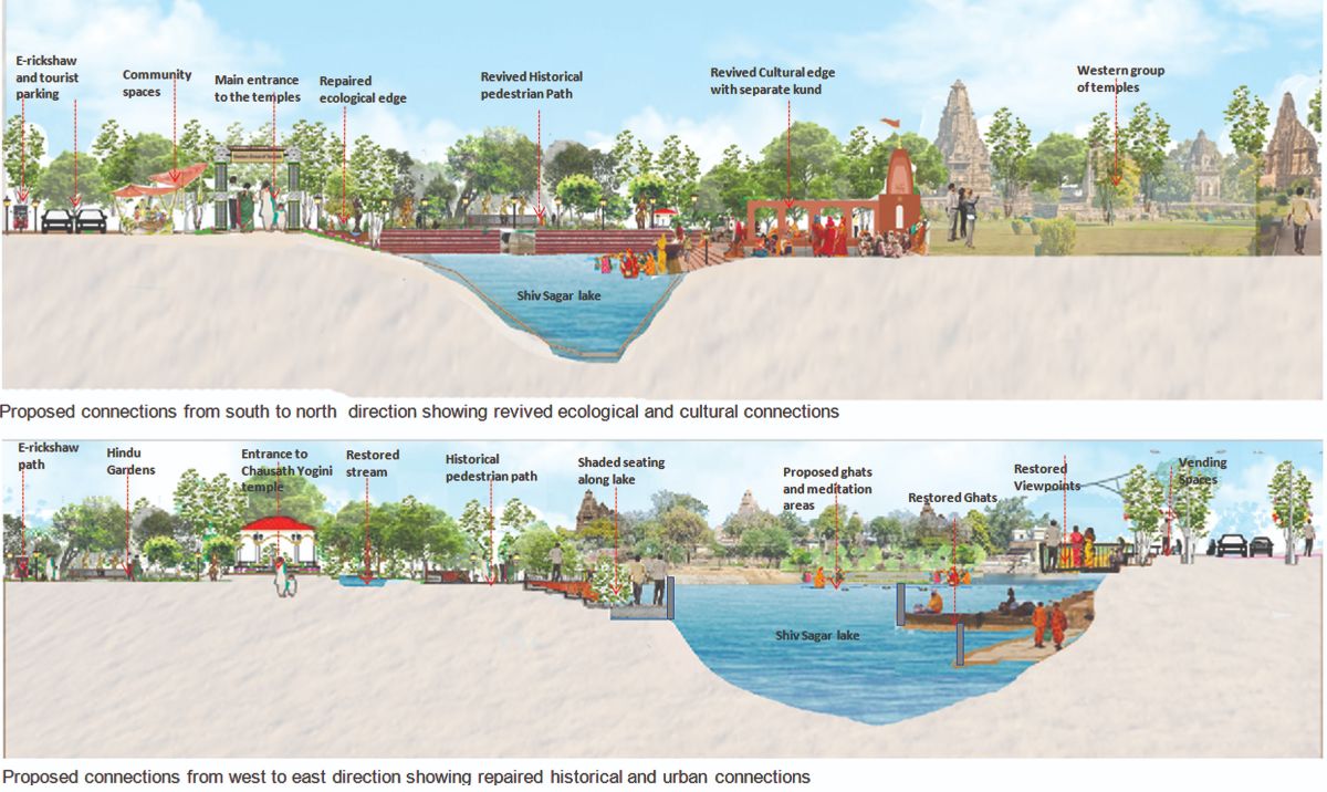
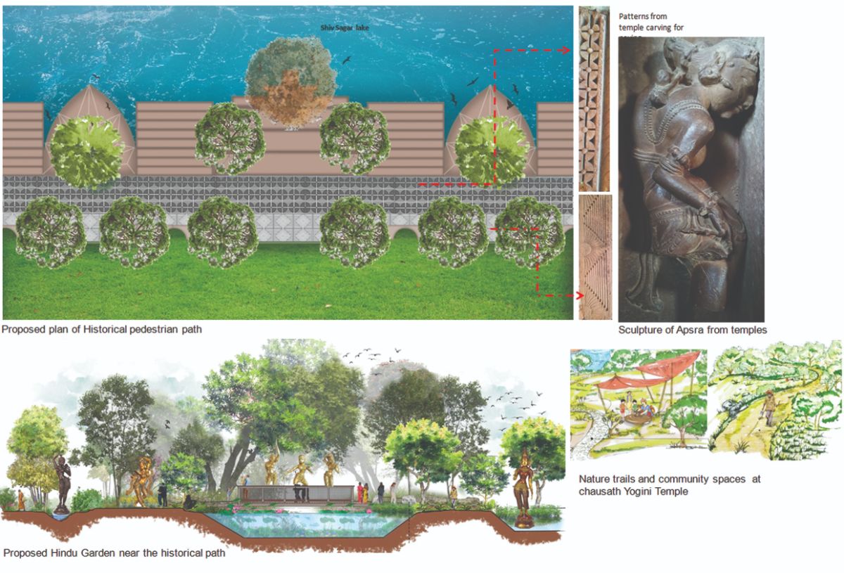
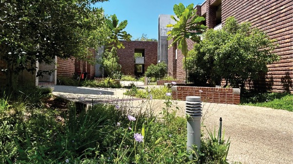
Understanding the cultural richness and layered heritage of Khajuraho, the historical pedestrian path has been provided to connect the Chausath Yogini temple to the western group of temples, with the ghats and seating spaces enhanced to address Shiv Sagar Lake. The geometric paving patterns on the paths draw inspiration from temple carvings, reconnecting with the era's architectural expression. The surrounding open spaces along the path have been designed using the concept of sacred Hindu gardens by restoring the seasonal well and providing rain gardens, flower gardens, natural trails, fruit orchards, and mythological trees.
Rejuvenation of water edges
The cultural edge has been restored by providing designated ghats for ritual activities during festivals, a separate kind for sacred bathing, and dedicated meditation areas. Indigenous trees have been planted along the southern edge for birdwatching to increase biodiversity. Viewpoints and designated vendor spaces have been introduced along the eastern edge to prevent illegal parking and encroachment.
Diversion of vehicular and pedestrian movements and parking areas
The relocated entrance has been defined with proper signage. E-rickshaw parking, tourist parking, and the information centre have been provided near the Chausath Yogini temple, and the E-rickshaw movement road has been provided separately from the historical pedestrian path.
Provision of open green community spaces and workshops
Community spaces for promoting local crafts and sculpture, meditative areas, and seating areas with natural trails have been provided near the Chausath Yogini temple.
Figure 12 shows the proposed comprehensive urban landscape management plan. Figure 13, showing revived connections around the Shiv Sagar lake and temple premises. Figure 14, showing the details of the historical path, paving details, gardens and natural trails.
Conclusion
While dealing with such culturally rich landscapes, urban design frameworks should incorporate heritage concerns to ensure that the goals of urban development and heritage protection are compatible.
The methodical process of controlling and guiding the use and expansion of land, urban surroundings, urban infrastructure, and related ecosystems should enable optimal economic growth, improve general well-being, encourage sustainable resource management, and ensure the efficient operation of infrastructures.
References
References
Ahmad, L., & Tripathi, S. (2024). Trends and Patterns in the Growth of Tourist Flow in Khajuraho Bundelkhand during the Last Two Decades. Annals of Forest Research, 67(1), 225-242.
Al-hagla, K. S. (2010). Sustainable urban development in historical areas using the tourist trail approach: A case study of the Cultural Heritage and Urban Development (CHUD) project in Saida, Lebanon. Cities, 27(4), 234-248.
Cohen, N. (2010). Planning the urban Web: Tel Aviv – A case in point [Online] (2010) Google Scholar
Dhingra, M., Singh, M. K., & Chattopadhyay, S. (2017). Macro-level characterisation of Historic Urban Landscape: Case study of Alwar walled city. City, culture and society, 9, 39-53.
Dhingra, M.K. (2014). Inclusive revitalisation of distressed Settlement: Case study- historic district of Alwar Walled City in Rajasthan, IIT Kharagpur, Kharagpur.
Gogogi, (2017) .Khajuraho Heritage Region: Conservation and Sustainable Development Strategy. Development Alternatives Newsletter. http://www.devalt.org/newsletter/mar00/of_1.htm. Retrieved on August 4, 2017.
Gupta, A.K., Nair, S.S., Ghosh, O., Singh, A. and Dey, S. (2014). Bundelkhand drought: Retrospective analysis and way ahead. National Institute of Disaster Management, New Delhi, 148.
Guzmán, P.C., Roders, A.P. and Colenbrander, B.J.F. (2017). Measuring links between cultural heritage management and sustainable urban development: An overview of global monitoring tools. Cities, 60, pp.192-201.
Haumann, S., Knoll, M., & Mares, D. (2020). Concepts of urban-environmental history (Vol. 1). transcript Verlag.
Khajuraho Master Plan 2031, (2019) . http://mptownplan.gov.in/LU panel/Chhatarpur/khajuraho%20DP%20draft%202031.pdf
Lingis, A. (1979). Khajuraho. Soundings, pp.52-69.
Louise N. (2007), India, National Geographic Society, ISBN 978-1426201448,
Mainaly, S. H. (2023). Non-Western Rendition of Ambient Rhetoric of Khajuraho Monuments.
Mumford, J. (2021). Ecstasy through tantra. Llewellyn Worldwide.
Orr, L.C. (2018). Temple: Form and Function. Brill Encyclopaedia of Hinduism, 2.
Pati, G. (2011). Temple and human bodies: Representing hinduism. International Journal of Hindu Studies, 15(2), pp.191-207.
Pecherskaya, E. P. Dzhabborova, L. V., Averina, L. V., Firulina, I. I., Ivankina, M. S., & Akopyan, D. A. (2018). Cultural heritage sites' protected areas as a tool of urban environment development. EurAsian Journal of BioSciences, 12(2), 189-194.
Poggi, et al. (2017). Khajuraho: Indian Temples and Sensuous Sculptures. 5 Continents Editions. p. 9. ISBN 978-88-7439-778-5.
Prakash, B., (2024). An Epigraphical and Architectural Study of Socio-economic and Cultural Aspects of Khajuraho Temples.
Punja, S. (2010). Khajuraho: The First Thousand Years. Penguin UK.
Ray, H. P. (2023). The Hindu Temple and Its Sacred Landscape. Simon and Schuster.
Šćitaroci, M. O., Šćitaroci, B. B. O., & Mrđa, A. (Eds.). (2019). Cultural urban heritage: development, learning and landscape strategies. Springer.
Sharma, A. (1999). The Purusārthas: an axiological exploration of Hinduism. Journal of Religious Ethics, 27(2), pp.223-256.
Sharma, A., & Aulakh, R. S. (2023). Historic Urban Landscape Recommendation in Indian Heritage Management Policies. The Historic Environment: Policy & Practice, 14(4), 428-443.
Sharma, A., Upadhyay, N. and Chani, P.S. (2019). Establishing architectural typology of eighteenth-century Bundeli gardens—characteristics and extent, with reference to the gardens of Rajnagar/Khajuraho. Landscape History, 40(2), pp.101-126.
Singh, J. (2021). Cultural & Architectural Heritage Tourism: Sustainable Development: A Case Study of Khajuraho. Journal of Psychology and Education, Vol. 58 (2), pp-1004-10013.
Singh, R. (2009). Cosmic Order and Cultural Astronomy: Sacred Cities of India. Cambridge Scholars Publishing.
Singh, R.P. (2024). Hindu pilgrimage places & archetypal representation: the pathway to reconnecting with your culture.
Singh, R.P. and Rana, P.S. (2017). Sacred geography of Hindu holy places. History of Ancient India, 11.
Singh, S. (2025). Heritage Preservation and Political Legitimisation: Creating a Usable Past in Gwalior State. South Asia: Journal of South Asian Studies, pp.1-23.
Slaczka, Anna. “Temples, Inscriptions and Misconceptions: Charles-Louis Fábri and the Khajuraho ‘Apsaras.’” The Rijksmuseum Bulletin 60, no. 3 (2012): 212–33. See p. 217
Som, J., Chatterjee, S., & Suklabaidya, P. (2020). Stakeholders' Perspective on Tourism Infrastructure at Khajuraho Dance Festival. Global Journal of Enterprise Information System, 12(2).
Srivastava, S. (2018). Khajuraho: Tourism and Its Impact. Journal of Multidisciplinary Studies in Archaeology, 6, 1115-1125.
Tweed, C., & Sutherland, M. (2007). Built cultural heritage and sustainable urban development. Landscape and urban planning, 83(1), 62-69.
Vedic Tribe. (2020). Hindu Temple and the structure of the human body. https://vedictribe.com/uncategorized/vaastu-shastra-hindu-temple-and-the-structure-of-human-body/
Verma, M. and Pal, A. (2019). Species diversity, dominance and equitability in tropical dry deciduous forest of Bundelkhand region, India. Biodiversity International Journal, 3(4), pp.145-154.
Vijayakumar, S. (2017). The Sacred and the Sensual. Experiencing Eroticain Temples of Khajuraho. Via. Tourism Review, (11-12).


.jpg)
