Bo Kaap Market – The Design of Everyday Infrastructure through Discovery, Layered Ground and Everyday Memory
ABout the Author/s


Le marché de Bo-Kaap – La conception d’infrastructures quotidiennes à travers la découverte, les strates du sol et la mémoire collective
Les espaces publics multifonctionnels jouent un rôle central dans la réinvention de la vie urbaine, en particulier au sein des quartiers chargés d’histoire. Le marché de Bo-Kaap, réalisé dans le cadre du mandat de développement économique de la ville du Cap, constitue une étude de cas en matière de conception réactive, capable de s’adapter aux multiples impératifs sociaux, écologiques et patrimoniaux qui le sous-tendent. Le marché est situé au sein d’un nœud urbain identifié dans le Cadre de développement spatial local de Bo-Kaap, à l’intersection de Wale Street, Yusuf Drive et Pentz Street. Le site se caractérise par la convergence des voies de circulation et par le point de rencontre entre la colline et la ville (Ville du Cap, 2021). Ce positionnement inscrit le projet comme une insertion stratégique au sein d’une structure urbaine existante, où l’ordre spatial du marché est façonné par une séquence de transpositions entre le site et la conception.
Les contraintes environnementales et topographiques sont devenues un moteur principal de la conception. La préservation des figuiers Ficus natalensis matures, dotés de systèmes racinaires étendus et exposés, a nécessité une alternative à l’aménagement minéral conventionnel, ce qui a abouti à la mise en place d’un platelage soigneusement positionné pour surélever les activités au-dessus des zones de protection des racines, préservant ainsi la santé des sols tout en maintenant la perméabilité.
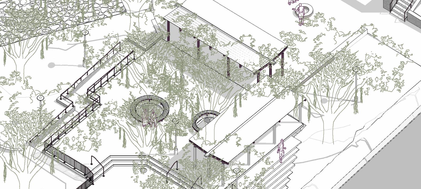
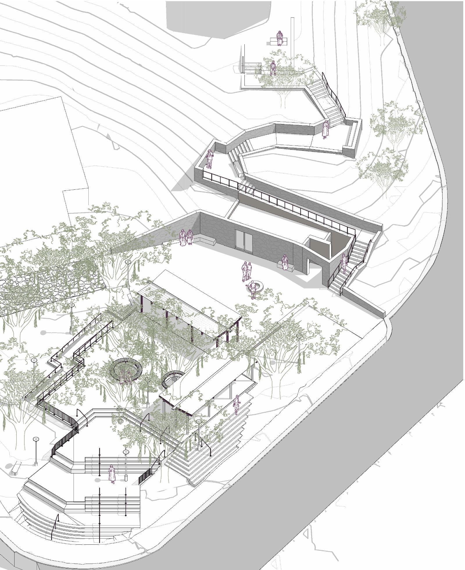
En tant que stratégie spatiale, le marché réinterprète la topographie comme une opportunité plutôt que comme une contrainte. Un système de plates-formes en bois et en acier disposées en gradins permet de franchir un dénivelé de quatre mètres afin de créer une cour collective et un « escalier vivant » qui accueille le commerce, les rassemblements, la circulation et les moments de pause au sein d’un cadre unique et intégré. Cette approche multifonctionnelle permet à l’espace de passer de l’activité du marché à l’usage social quotidien et aux rassemblements civiques, illustrant ainsi comment une infrastructure réactive et adaptable peut renforcer la résilience économique et la connectivité sociale sans formaliser à l’excès le commerce informel.
Le projet illustre en outre les réalités du travail dans des contextes riches en patrimoine, où la conception doit évoluer au cours de la mise en œuvre de la phase 5. La découverte inattendue d’un puits historique en pierre en 2025 a nécessité l’arrêt immédiat des travaux dans un rayon de cinq mètres et la restructuration du projet en deux phases. Plutôt que de compromettre le projet, cette découverte l’a recalibré. La phase 2 redéfinit le puits comme un point focal culturel, en introduisant de larges marges de recul, une ouverture visuelle et une ligne de construction sobre qui met en valeur à la fois le puits et la maison Spolander adjacente, la plus ancienne demeure du Bo-Kaap.
Introduction
Multifunctional public spaces are pivotal in reimagining urban life, especially within historically significant neighbourhoods. The Bo-Kaap Market, delivered under the City of Cape Town’s economic development mandate, operates as a case study in responsive design that adapts to the layered social, ecological and heritage imperatives that inform it. The Market is situated within a civic node identified in the Bo-Kaap Local Spatial Development Framework at the intersection of Wale Street, Yusuf Drive and Pentz Street. The site is defined by the convergence of movement routes and where the hillside meets the city (City of Cape Town, 2021). This positioning frames the project as a strategic insertion within an existing urban structure, where the market’s spatial order is shaped by a sequence of translations between site and design.
Environmental and topographical constraints became a primary design driver. The preservation of mature Ficus natalensis trees, with extensive, exposed root systems, required an alternative to conventional hard landscaping, resulting in decking and carefully positioned to elevate activity above root protection zones, protecting soil health while maintaining permeability.
As a spatial strategy, the market reframes topography as an opportunity rather than a limitation. A system of stepped timber and steel platforms negotiates a four-metre level change to create a collective court and “living stair” that accommodates trading, gathering, circulation and pause within a single integrated framework. This multifunctional approach allows the space to shift between market activity, everyday social use and civic gathering, illustrating how responsive and adaptable infrastructure can enhance economic resilience and social connectivity without over-formalising informal trade.
The project further exemplifies the realities of working in heritage-rich contexts where design must evolve during implementation. The unexpected discovery of a historic stone well in 2025 necessitated the immediate cessation of works within a five-metre radius and the restructuring of the project into two phases. Rather than compromising the scheme, this discovery recalibrated it. Phase 2 reframes the well as a cultural focal point, introducing generous setbacks, visual openness and a restrained built edge that foregrounds both the well and adjacent Spolander House, the oldest home in the Bo-Kaap.
This article, therefore, traces the Bo-Kaap Market’s design translations that convert site conditions and disclosures, including topography, access geometry, canopy and extensive root systems, heritage sensitivities, and the later discovery of a historic well, into legible civic form. Construction-phase discoveries are moments in a longer conversation with the site, spanning stages and scales. Through this evolution, the Bo-Kaap Market demonstrates how adaptive and responsive design can transform constraint into opportunity, integrating informal economy, ecological care and collective memory within a coherent public realm.
Context and positioning
Understanding the Bo-Kaap Market requires attention to the wider spatial and cultural structure of the Bo-Kaap itself. The Bo-Kaap is considered a major tourism destination known for its colourful streetscapes and rich cultural history. The historic neighbourhood is widely recognised as a significant cultural landscape in Cape Town (City of Cape Town, 2021), shaped by a tight grid of residential streets, strong topographical gradients, and a network of pedestrian routes linking the lower city to Signal Hill.
The Group Areas Act of 1950 reshaped many well-located neighbourhoods through racial segregatory zoning, resulting in forced removals from areas designated for white residents and, in the case of District Six, the demolition of the entire neighbourhood. The Bo-Kaap has long been associated with Cape Malay cultural life, with a long local history of Islamic practices. Under apartheid, the area was subject to racial classification. However, unlike District Six, which was declared a “white area” and subsequently demolished, the Bo-Kaap was designated a “Malay area”, which helped it avoid demolition.
The neighbourhood’s significance lies in both its enduring built form and its cultural endurance amid changing political and economic conditions. Intergenerational cultural traditions are sustained through everyday routines, religious traditions, community events and a longstanding use of the street as a gathering space that remains central to place identity and civic life. Significance is anchored in cultural associations that accumulate over time and use, thereby making the conditions of existing place and memory materially relevant to design decisions (Treib, 1995). Urban form in such settings is best understood as the cumulative outcome of accretion and adaptation. The account of the city as a collage (Rowe and Koetter, 1978) offers a useful framework for considering this condition. Here, interventions are seen as insertions into an existing field and are judged by how they reinforce existing relations, in this case of trade and movement, as much as by what they introduce.
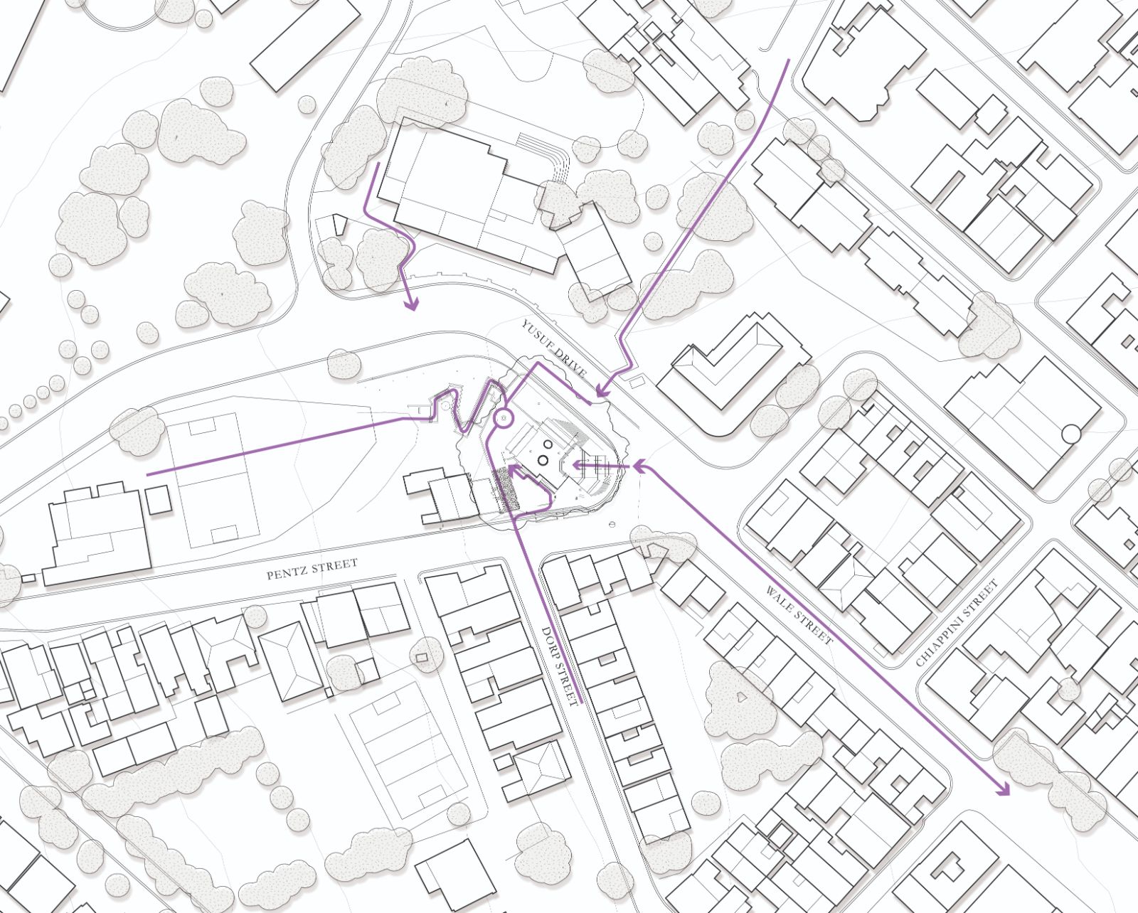
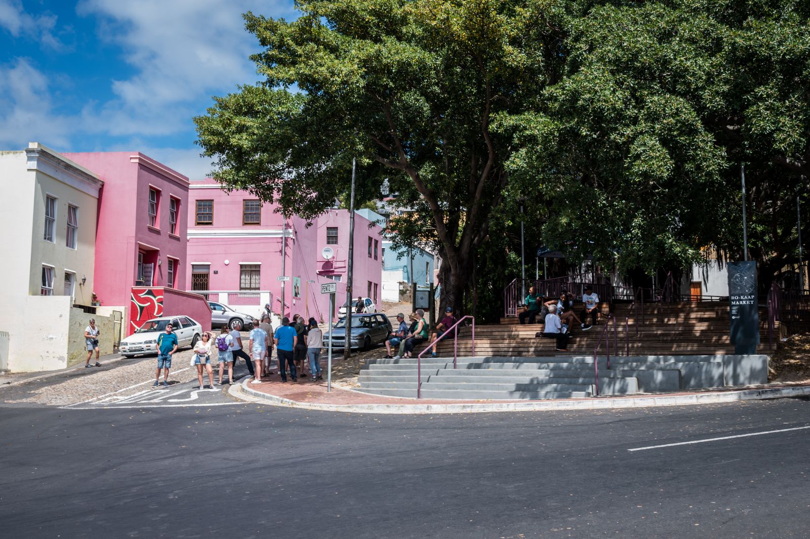
The Bo-Kaap Local Spatial Development Framework identifies the intersection of Wale Street, Yusuf Drive and Pentz Street as a key civic node and destination (City of Cape Town, 2021). It needs to reinforce continuity of movement while allowing for the intensities and routines of trade. It also needs to hold a sensitive heritage context through placement, openness, and restraint, including visual relationships to nearby heritage assets such as Spolander House. The market is responsible for tying together a legible spatial and civic moment. Further, as the market is located within a neighbourhood that is a major tourism destination, there is an additional layer of responsibility to design with local sensitivity. The work needed to support local trading, gathering, and the routines of everyday life first, while providing opportunities to support both economic growth and everyday use beyond the aesthetics of tourism. The site needed to function on days without events, relying on routine use by the surrounding neighbourhood to activate the space.
The Bo-Kaap Market is registered in gradient, routes, edges, inherited view relationships, and the everyday patterns of use that precede formal intervention. Therefore, the market is approached through the lens of design with discovery, treating the site as an archive of accumulated layers, fragments and infrastructures that influence what public space can become.
The market as everyday civic infrastructure
The market was conceived as a public space that supports informal trade while remaining available for everyday social use and civic gathering. The public space, therefore, needs to work across temporalities, where social life and spatial form are continuously made in practice rather than fixed by programme alone (Lefebvre, 1991). It functions as a market during trading hours, a social space for residents and visitors outside peak trading, and a gathering space for events.
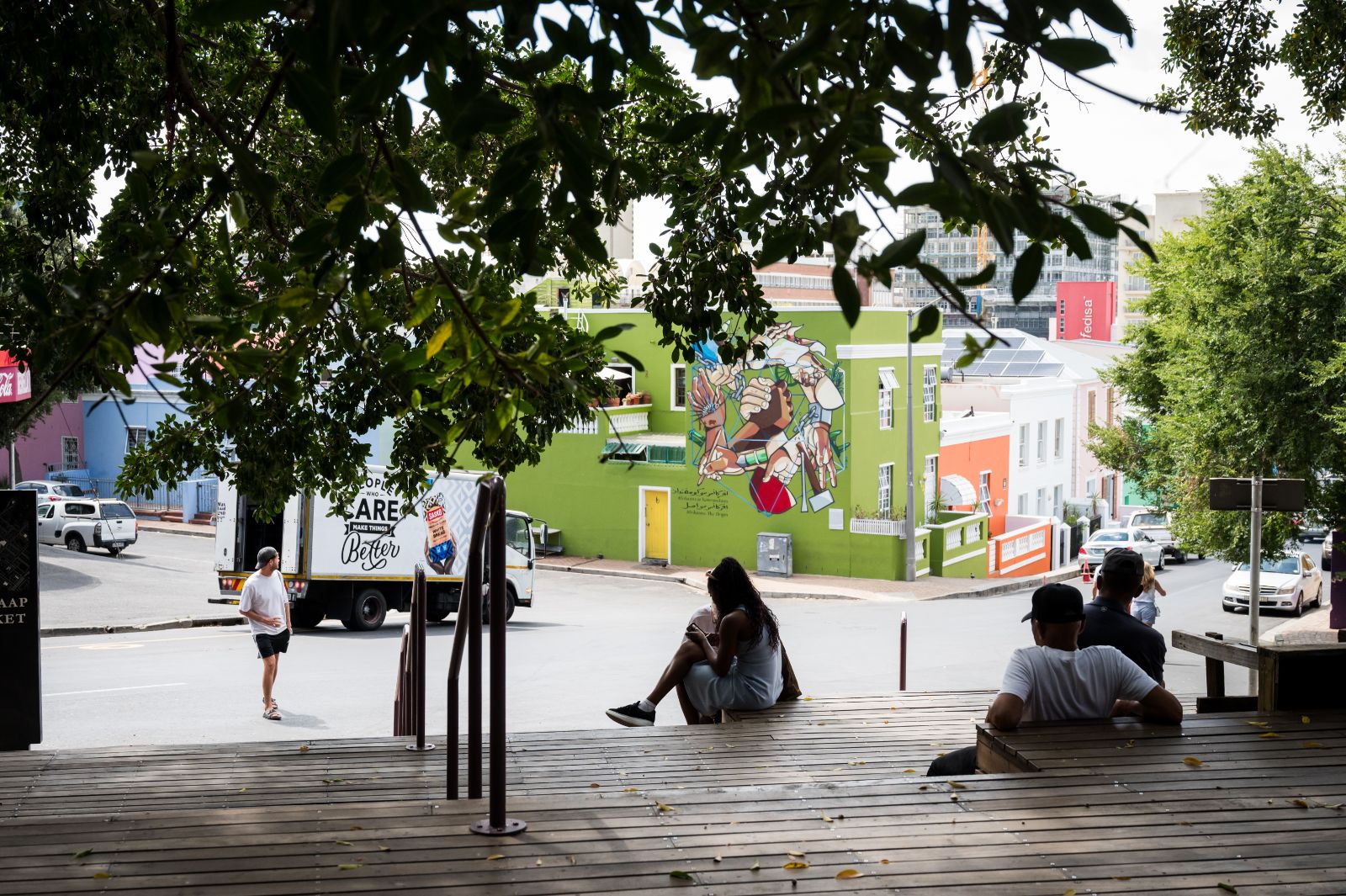
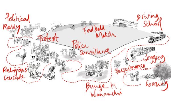
Openness and permeability are central to this civic function as well as its temporal flexibility. Multiple access points and open edges without fencing maintain continuity with pedestrian desire lines and neighbourhood movement, strengthening the space's readability as a node at the confluence of many routes and allowing people to orient themselves within the neighbourhood (Lynch, 1960). Clear sightlines, defined routes, and the sustained presence of people occupying the site support passive surveillance. Safety is seen as linked to ordinary presence and oversight generated by daily routines, and to the capacity of public space to hold overlapping uses that keep eyes on the street (Jacobs, 1961). The market activates the space during trade days, and the City of Cape Town maintains a presence on the site. The space is also visible from the surrounding houses, and people from the neighbourhood gather to play games, occupy the steps and observe the street from this vantage point of its timber platforms. The market’s publicness is therefore maintained through spatial decisions that support use and mutual visibility rather than through controlled access.
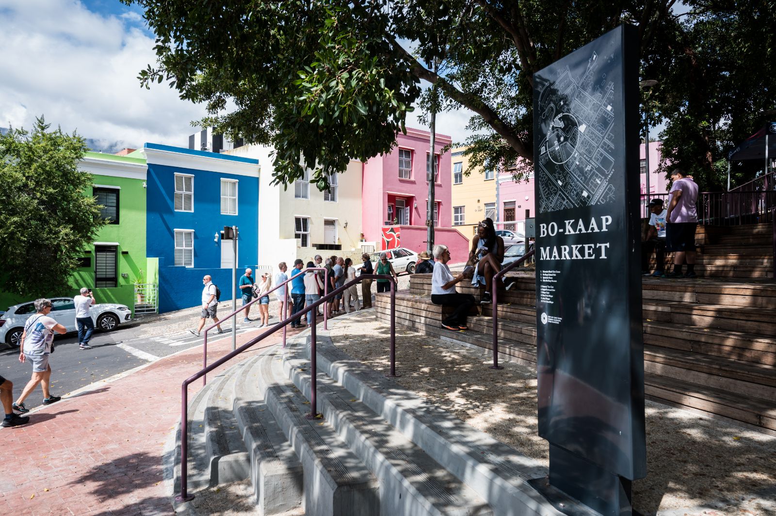
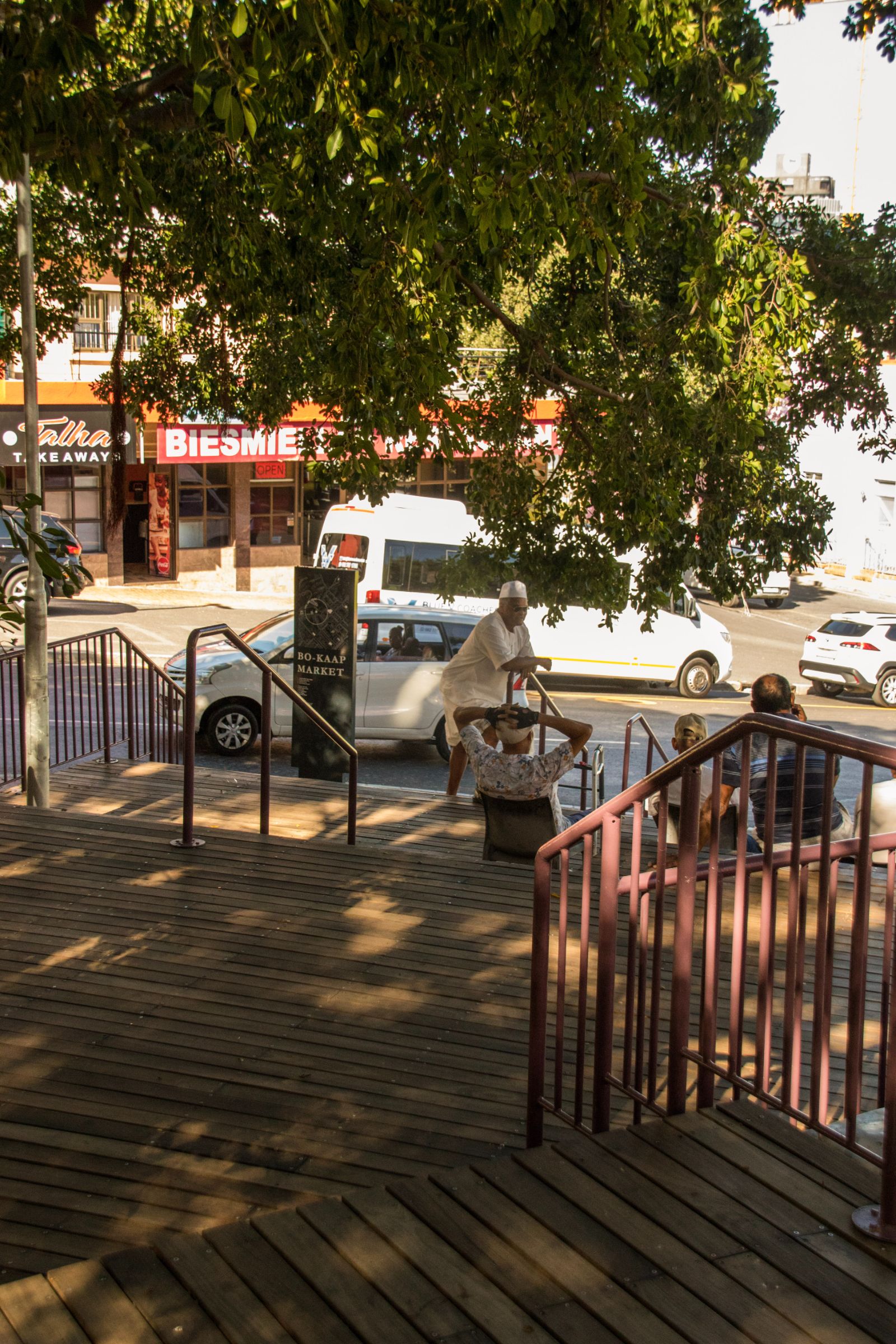
Topography also contributes to civic infrastructure, because section conditions shape how people occupy space. Where landings, edges, and seating opportunities are integrated into movement routes, people are more likely to pause, observe, and remain. Gehl describes how improvements in the quality of public space are reflected in increased opportunities for optional activities and longer durations of “staying activities” (Gehl, 2010). This emphasis on staying also aligns with accounts of landscape performance that include lived experience and cultural use alongside technical function (Meyer, 2008). In a market context, this relationship matters because the distinction between passing through and staying often determines whether a space feels merely transactional or genuinely civic. The market’s infrastructure is therefore social and spatial at once, where design can increase the legibility of those systems within everyday public life.
Translating the site into civic form
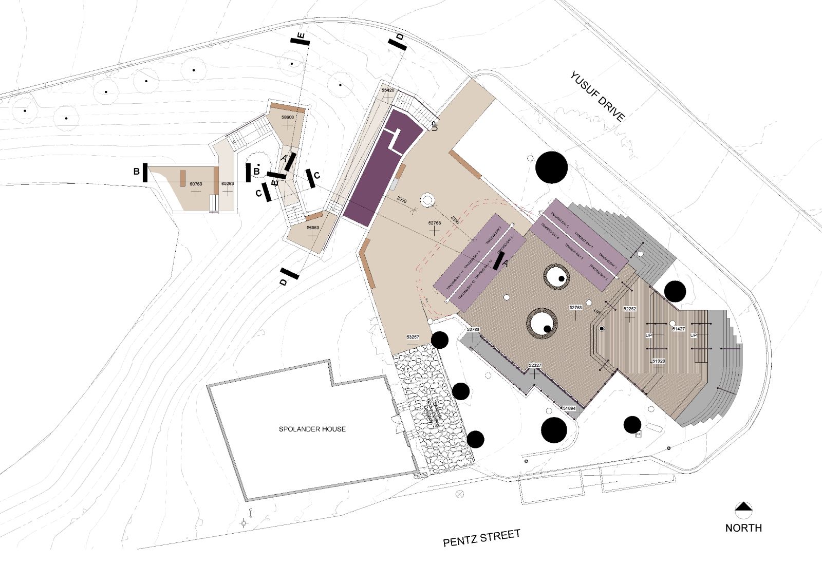
Design with discovery describes a project logic in which the site becomes the archive that informs decisions across stages. Some of the informing conditions were visible early. The steep gradient was present from the outset. Movement routes and node conditions were legible in daily arrival patterns. Heritage sensitivities and visual relationships were also part of the early reading. The initial conceptual work for the market site was undertaken by TKLA, establishing the need to protect the trees' roots and to lift the structures above the ground. This initial concept also established the language and set out the trade bays.
The below-ground extents of tree roots were established through excavation and on-site work. The discovery of the historic well, made during construction in 2025, significantly altered the design. These later disclosures required reorganisation and iterative reframing as the site sequentially revealed realities that could not be fully resolved in advance.
Negotiating slope and structuring arrival
The market site includes an approximate four metre level change from the Street intersection to the slope behind the site. The design treated this gradient as a primary driver and organised the public realm through stepped platforms and terraces. These sectional moves structured the space as a sequence of landings negotiated by seat edges and living stairs that support movement and pause. The elevated position affords views into and across the Bo Kaap to the Cape Town CBD beyond, reinforcing the market’s role as a destination and a place to linger within the movement network.
The site’s topography is further complicated by the fact that it was established over time as dumped fill. “It is clear from the stratigraphy of the sections seen in trenches on site that the current ground level has been considerable transformed by consecutive dumping events. This is consistent the pattern of material being brought in from elsewhere and dumped on the site.” (Clift, 2025) This has resulted in a new form of landscape, with uneven bearing capacity that holds traces of the past.
Trees of Note: Canopy, roots, and floor
The site is categorised as a green open space defined by a series of large Ficus natalensis trees, which have been identified as ‘of note’ by the City of Cape Town. These trees significantly contribute to the character of the space and to environmental comfort. The extensive root systems of the Ficus trees became a governing condition for how the public realm could be assembled, particularly regarding compaction and disturbance.
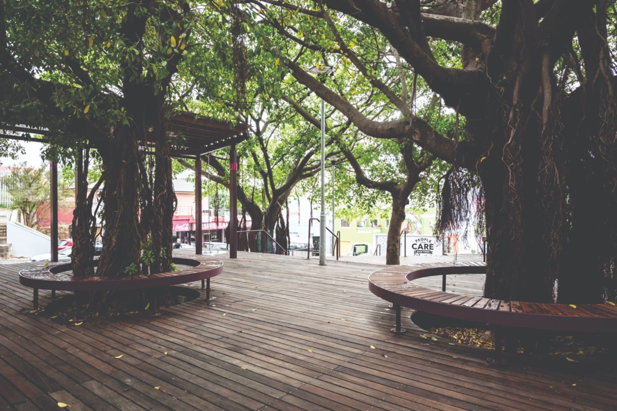
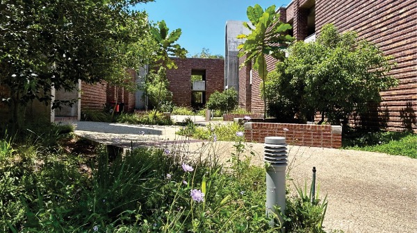
Lightweight timber construction, seating, and lightweight steel trade bays elevate activity above the sensitive root zone and allow water to permeate and infiltrate to the roots below. Trade bays were positioned in areas already affected by prior construction, and the design was continually adjusted to accommodate on-site discoveries. This necessitated a highly cooperative relationship between AR Projects, the main contractor and the design team.
Corner’s account of mapping helps to describe this process. Mapping is seen as an active instrument that organises relations and makes selected realities operational within design decisions (Corner, 1999). The delineation of root extents and protection requirements informs where the structure can land, how edges are resolved, and how surfaces connect across level changes.
During construction, the extent of the Ficus root zones became evident in areas where roots were exposed, triggering additional tree and root protection measures, limiting pruning and filling exposed root voids with fine washed gravel.
The consequences of these decisions extend beyond completion as care within practice that sustains urban life through attention to what already exists (Mattern, 2018). The deck establishes a continuous civic floor above the ground plane, capable of supporting trading, movement, and informal seating within an existing microclimatic structure.
Access, edges and permeability
The civic node condition of the site places particular emphasis on openness. Multiple points of entry from Pentz Street and Yusuf Drive require legibility without fencing the site. This involves consolidating desire lines into recognisable routes while keeping edges open and permeable. The site is structured to absorb pedestrian movement from all sides, offering a space of rest and refuge on the hill.
Of particular note is the Phase 2 proposed extension of Dorp Street. This continuation of the street highlights the historic urban form and reinstates access through the space at the site's original level. The market acts as a stair that receives pedestrians from the important axis of Wale Street, while also serving as a continuation of Dorp Street leading to the well and as a gathering space.
Subtle devices, such as changes in level and materials, define routes and pauses without hard boundaries. Avoiding fencing is a key urban design decision because enclosure can diminish a place's public character and hinder its integration with surrounding routes. When routes are clear and edges do not create concealed pockets, passive surveillance is strengthened through ordinary occupation.
Heritage sensitivities and spatial restraint
The market’s heritage setting has informed decisions about placement and openness. The adjacent heritage assets of Spolander House, which is still occupied as a home and is the oldest house in the Bo-Kaap, are a declared national heritage resource and a key visual anchor within the landscape. Care has been taken to respect Spolander house, with its modest architecture, through placement, setbacks, and careful control of what occupies the foreground.
The well and resurfaced infrastructure
The discovery of a historic well during construction in 2025 introduced direct spatial consequences. The well is a material trace of prior infrastructural arrangements and daily water-use practices. Its location and protection requirements reshape decisions about placement, clearance, and phasing.
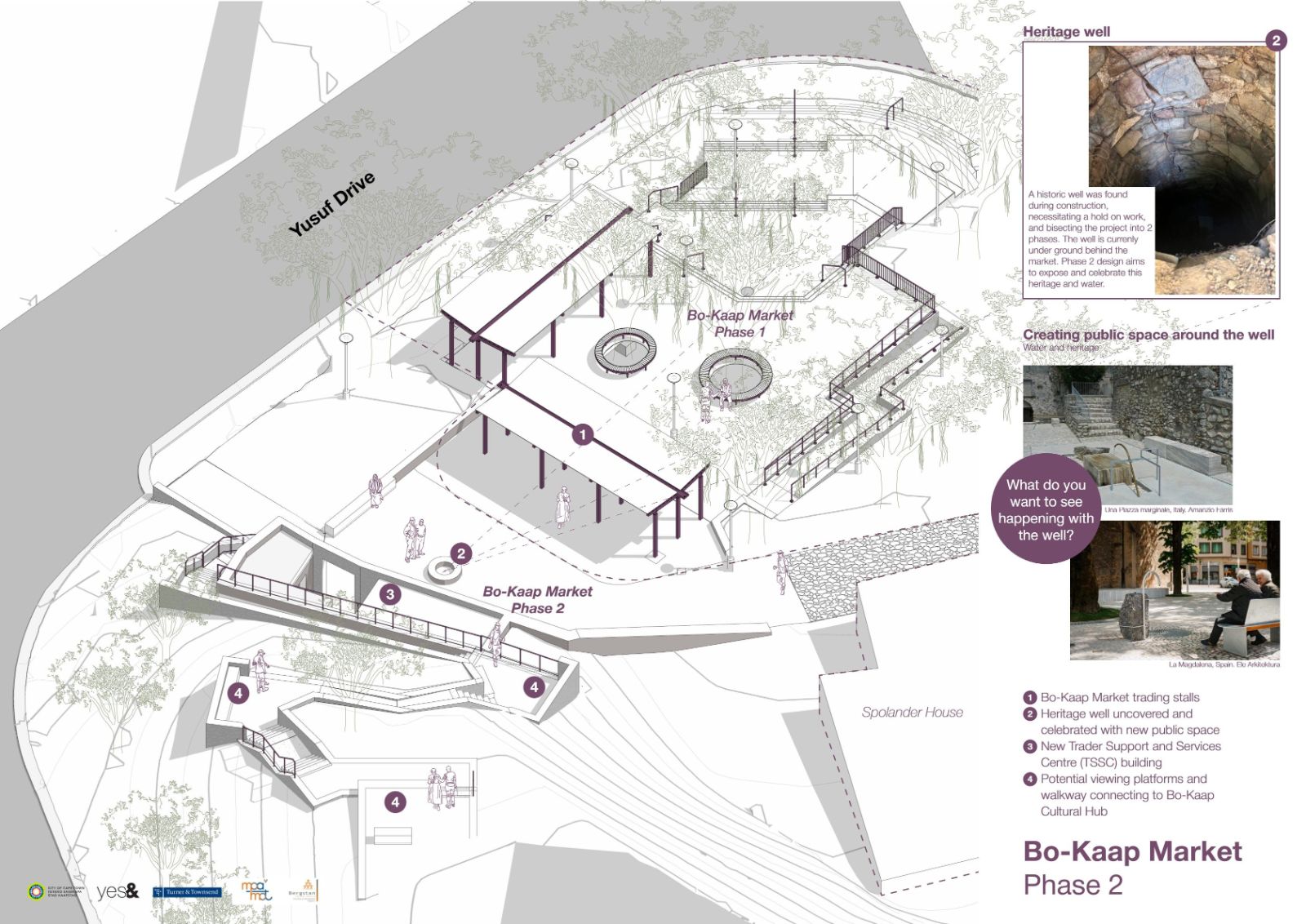
When the historic well was uncovered, work in its immediate vicinity was stopped, and the discovery was referred to Heritage Western Cape for direction. The well was to be stabilised and preserved in situ, which required the Trader Support Services building on site to be repositioned and the outstanding support functions to be deferred into a second phase. This effectively bisected the project into two phases, with the building and public space surrounding the well to be delivered in Phase 2. In parallel, an additional heritage process was initiated, including the preparation of urban design and heritage indicators to guide the revised proposal and frame how the well would be exposed, protected, and integrated into the public realm. Subsequent work was organised around the well through a courtyard logic that holds it within a publicly legible spatial field.
The design changes are intended to support a mode of collective memory grounded in daily encounter. The well will be experienced through routine movement and occupation. Its presence can orient circulation, create a point of pause, and provide a shared reference in everyday use. The intervention binds material trace to lived public space. This serves as an example of how urban water infrastructure shapes the modern city while remaining largely concealed (Gandy, 2004). The resurfacing of water infrastructure underscores how civic spaces are shaped by buried systems that structure urban life yet remain largely unseen, and demonstrates how such systems can become spatial anchors for collective memory when they are made legible within everyday routines (Gandy, 2004). The well can be read as a moment of visibility within this infrastructural layer, newly legible through construction, prompting a new understanding of the site and a re-composition of civic form around a disclosed substrate.
Conclusion
The market’s spatial order develops through correspondence with the site as an archive. Gradient shapes the sequence of landings and terraces and supports patterns of staying that reinforce the site as a destination. Existing movement routes guide permeability and legibility. The canopy and shallow roots shape a light-touch public realm and support environmental comfort. Heritage sensitivities and the well-organised work centred on a newly legible element, introducing a further layer of spatial orientation and shared reference. These translations strengthen the relationship between civic programme and place and support public-realm performance understood as both environmental and cultural. Collective memory is carried through everyday encounters, supported by a configuration that allows trading and gathering in relation to elements that materially anchor the place.
The Bo-Kaap Market suggests a way of thinking about public space in layered urban contexts where discovery is expected and where the site is understood as an archive with spatial and social consequences. All stages from analysis to construction unearth sources of design cues, clarifying what must be protected, what can be transformed, and what can be made publicly legible. These decisions support the daily work of informal trade while enabling pause, gathering, recognition, and ordinary sociability through which public space becomes socially productive.
An adaptive process makes room for iterative reframing as new information emerges, thereby supporting closer correspondence between civic space and the site's material conditions. In this reading, the market becomes richer because it is shaped by sustained attention to what the site discloses and by the spatial consequences those disclosures have in the ordinary life of the public realm.
References
References:
City of Cape Town (2021) Bo-Kaap Local Spatial Development Framework. Cape Town: City of Cape Town.
Clift, H. (2025) Bo Kaap Trading Facility Phase 2. Annexure A. Heritage Indicators. Historical Well Stabilisation Close Out Report. City of Cape Town, dated 1 October 2025.
Corner, J. (1999) ‘The Agency of Mapping’, in Cosgrove, D. (ed.) Mappings. London: Reaktion Books.
Gandy, M. (2004) ‘Rethinking urban metabolism water, space and the modern city’, City, 8(3), pp. 363–379.
Gehl, J. (2010) Cities for People. Washington, DC: Island Press.
Jacobs, J. (1961) The Death and Life of Great American Cities. New York: Random House.
Mattern, S. (2018) ‘Maintenance and Care’, Places Journal.
Meyer, E.K. (2008) ‘Sustaining beauty. The performance of appearance’, Journal of Landscape Architecture, 3(1), pp. 6–23.
Rowe, C. and Koetter, F. (1978) Collage City. Cambridge, MA: MIT Press.
Treib, M. (1995) ‘Approaches to Significance in Recent Landscape Architecture’, Landscape Journal, 14(1), pp. 46–63.
Credits
Project implemented for the City of Cape Town, Area Economic Development, with support and thanks to the project implementing team, City of Cape Town Project Managers, Ward Councillors, and Aldermen. Special thanks to the community and traders of the Bo-Kaap
Project team:
Landscape Architecture for Detail Design and Implementation, and Phase 2: Yes& Studio with architectural input from Jackie James
Project Management and Quantity Surveying: Turner and Townsend
Landscape Architects: Phase 1 - TKLA for Stage 1 & 2
Engineering: Bergstan Consulting and Development Engineers
Construction: AR Projects
Photographs by Marike Franklin
Drawings by Yes& Studio


.jpg)
